


Latest Stories
INSIDER Imaging
Multispectral Airborne Reconnaissance System Completes First Flight
Collins Aerospace has successfully completed the first flight test of its newest Fast-Jet reconnaissance pod, the MS-110 Multispectral Airborne Reconnaissance system, on an...
INSIDER Defense
Soldier Insights Drive Army's Development of Mixed-Reality Training System
On a mid-August afternoon in central Texas, soldiers in combat uniform gather together, preparing to engage in realistic battlefield training. With temperatures...

Application Briefs Defense
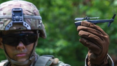
Nano-UAV Systems
Extremely light and well-suited for operations in contested environments, nearly silent, and with a flight time up to 25 minutes, the combat-proven, pocket-sized Black Hornet PRS transmits live video and HD still images back to the operator.
News Power
SAE International Extends Call for Abstracts, Seeks Submissions for AeroTech Conference
Engineering Events staff at SAE International in Warrendale, Pennsylvania, have extended the call for abstracts through September 21 for the...

Application Briefs Aerospace
Cryogenic Thermal Subsystem
The Cryogenic Thermal Subsystem’s most critical function is to provide cooling to maintain the detectors in two of the Roman Coronagraph Instrument’s cameras at sufficiently low temperatures of approximately minus 161o F, which will allow them to function with the required sensitivity.

Articles Photonics/Optics
Designing A/D Converters for the James Webb Space Telescope
The James Webb Space Telescope (JWST) has four infrared cameras to view the stars.

Application Briefs Unmanned Systems
Vehicle-Mounted Tactical Radars
Blighter will be supplying its B422 180-degree ground surveillance e-scanning radar in a vehicle-mounted configuration to be fitted to a six-wheeled UGV.

Application Briefs Imaging
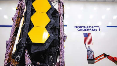
Cryocooler Technology
Northrop GrummanFalls Church, VA215-675-4949www.northropgrumman.com NASA’s James Webb Space Telescope, built in partnership with Northrop Grumman Corporation, is one step closer to being fully commissioned. Enabled by...
Briefs Imaging
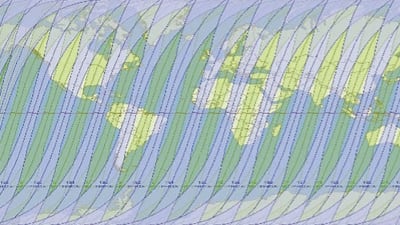
Modeling Space-Based Intelligence, Surveillance, and Reconnaissance (ISR) in Combat Simulations
During the 2021 Modeling and Simulation (M&S) Gap Forum, space intelligence, surveillance, and reconnaissance (ISR) modeling was identified as...
Articles Unmanned Systems
Using Underwater Robotics for Autonomous Deep-Sea Exploration
A decade ago, industries that needed to perform underwater inspection and maintenance had only one option: send a human diver into the water. In both the military and commercial...

Articles Photonics/Optics
Removing Aircraft Paint Using Laser-Equipped Robots
Hexavalent chromium is not a term frequently associated with engineers. Residents of Hinkley, California, however, know all about it. So do workers tasked with the labor-intensive process...

News Unmanned Systems
3DEO Launches New Metal 3D-Printing Platform
California-based 3DEO unveiled in February its new metal 3D printing platform and patented technology, Saffron. The proprietary platform has been in development for the past five years. “Until...

INSIDER Sensors/Data Acquisition
Research Could Lead to Noise Reduction in Aircraft Engines
Through a Small Business Innovative Research contract awarded to MetroLaser, Inc., by the U.S. Navy, a system is being developed to measure the gas velocity of engine exhaust to...

INSIDER Photonics/Optics
Mounted Troops to Get High-Tech Situational Awareness Tools
Mounted armored vehicles such as the Bradley have long been used as heavy weapons platforms with long range sensors to hunt targets and provide armored transportation to dismounted...

Articles Aerospace
Advancing Metrology at Mach Speed
Drone-mounted inspection tools are breaking barriers for the F-35.

Briefs RF & Microwave Electronics
Development of a 94 GHz Radar System for Dedicated Bird Detection at Airports and Airfields
BIRDAR™ detected small birds at distances of 1.2 to 1.3 km and large birds.

Application Briefs Photonics/Optics
Hybrid Thermal and Red Dot Sight
The advanced MIL-STD Mepro TIGON sight has arrived.

INSIDER Electronics & Computers
Egypt’s Apache Helicopter Fleet to Get Upgraded Sensor Systems
Lockheed Martin received a $102 million contract award to upgrade 25 of Egypt’s AH-64D Apaches to the E-model version of the aircraft. This modernization for the Egyptian...

INSIDER Photonics/Optics
Technology Companies Work to Combat Pilot Fatigue
Collins Aerospace and Seeing Machines, a leader in eye tracking and driver safety technology, are working together to develop and deliver revolutionary fatigue management technology...

Application Briefs Imaging
Long Range Uncooled Thermal Cameras
The Jaegar provides high levels of camera positioning accuracy.

Articles RF & Microwave Electronics
JADC2: Building the U.S. Military’s Internet of Things
The U.S. military's "Joint All Domain Command and Control" initiative wants to bring quick, seamless access to intelligence from any system in the battlefield.

Application Briefs Data Acquisition
Tactical Data Link Software
This was the first UAS application in a Navy exercise for the proven capabilities of LinkPRO software.
Products Robotics, Automation & Control
New Products
Data recorders, conduction-cooled chassis, robot chargers, and more.

Briefs Imaging
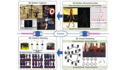
3D Data Acquisition Platform for Human Activity Understanding
A computational approach for action prediction can extend to machines and also promote further research in human prediction and intention sensing.
Briefs Imaging
Coastal Lidar and Radar Imaging System (CLARIS) Lidar Data Report
The Army analyzed shoreline change, dune volume, beach volume, beach slope, and cumulative elevation change along the northern Outer Banks of North Carolina.

Briefs RF & Microwave Electronics
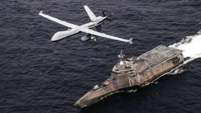
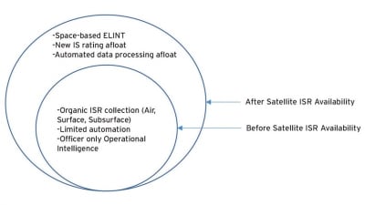
Impact of Satellite Intelligence, Surveillance and Reconnaissance on Modern Naval Operations
Army research is determining if afloat availability of satellite ISR has fundamentally changed naval operations.
News Energy
Industry Invited to Participate in AeroTech Aerospace and Defense Technical Program
SAE International is inviting global participation in its AeroTech® aerospace and defense technology conference and exhibition, which is for the first time...

News Unmanned Systems
Register Now: Counter UAS Technology 2021
The two-day event highlights cutting-edge products and services designed to protect DoD personnel, equipment, and infrastructure from hostile drones.

Application Briefs Aerospace
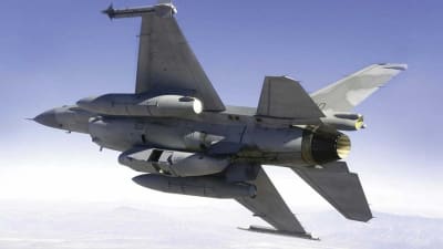
Fighter Jet Armaments
The F3-R Rafale generates images in both the visible and infrared ranges.

Top Stories
INSIDERDefense
![]() New Raytheon and Lockheed Martin Agreements Expand Missile Defense Production
New Raytheon and Lockheed Martin Agreements Expand Missile Defense Production
NewsAutomotive
![]() Ford Announces 48-Volt Architecture for Future Electric Truck
Ford Announces 48-Volt Architecture for Future Electric Truck
INSIDERManufacturing & Prototyping
![]() Active Strake System Cuts Cruise Drag, Boosts Flight Efficiency
Active Strake System Cuts Cruise Drag, Boosts Flight Efficiency
ArticlesTransportation
![]() Accelerating Down the Road to Autonomy
Accelerating Down the Road to Autonomy
INSIDERMaterials
![]() How Airbus is Using w-DED to 3D Print Larger Titanium Airplane Parts
How Airbus is Using w-DED to 3D Print Larger Titanium Airplane Parts
Road ReadyTransportation
Webcasts
Electronics & Computers
![]() Cooling a New Generation of Aerospace and Defense Embedded...
Cooling a New Generation of Aerospace and Defense Embedded...
Power
![]() Battery Abuse Testing: Pushing to Failure
Battery Abuse Testing: Pushing to Failure
Connectivity
![]() A FREE Two-Day Event Dedicated to Connected Mobility
A FREE Two-Day Event Dedicated to Connected Mobility
Automotive
![]() Quiet, Please: NVH Improvement Opportunities in the Early Design Cycle
Quiet, Please: NVH Improvement Opportunities in the Early Design Cycle
Transportation
![]() Advantages of Smart Power Distribution Unit Design for Automotive &...
Advantages of Smart Power Distribution Unit Design for Automotive &...
Aerospace
![]() Sesame Solar's Nanogrid Tech Promises Major Gains in Drone Endurance
Sesame Solar's Nanogrid Tech Promises Major Gains in Drone Endurance