


Coastal Lidar and Radar Imaging System (CLARIS) Lidar Data Report
An analysis of shoreline change, dune volume, beach volume, beach slope, and cumulative elevation change along the northern Outer Banks of North Carolina near the CHL Field Research Facility over a 6-year study period.
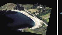
The dynamic nature of the nation’s coastlines necessitates frequent shoreline monitoring and mapping. The U.S. Army Engineer Research and Development Center, Coastal and Hydraulics Laboratory (CHL), Field Research Facility (FRF), has collected datasets on the nearshore zone’s changing conditions for over 40 years. During the course of these efforts, CHL has continued to develop different technologies to refine shoreline monitoring techniques, with a particular focus on the application of remote sensing technology to coastal monitoring. Light detection and ranging (lidar) scanners have proven useful for the CHL coastal measurement efforts, providing highly detailed data of coastal change and hydro-dynamic processes.
Lidar is frequently collected from stationary ground-based platforms, which provide fine detail (100s to 1000s of points per meter) in one location or mobile airborne sampling approaches that provide coverage over large areas but at lower resolution (1 to 10s of points per meter). The U.S. Army Corps of Engineers (USACE), U.S. Naval Oceanographic Office, and National Oceanic and Atmospheric Administration (NOAA) formed the Joint Airborne Lidar Bathymetry Technical Center of eXpertise in 1998 to support coastal mapping requirements and committed to surveying the U.S. coastline every 5 years with airborne lidar. As a result of these and other efforts, coastal monitoring with airborne lidar data has provided a range of insights into coastal change since the late 1990s.
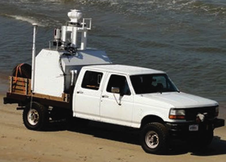
While airborne lidar sampling provides significant coverage, it also demands significant resources for deployment and may lack the temporal and spatial resolution necessary to adequately map the evolution of coastal features at scales relevant to the forcing conditions. To bridge the gap between airborne lidar coverage and terrestrial lidar scanner resolution and ease of deployment, CHL developed the Coastal Lidar and Radar Imaging System (CLARIS), a mobile, truck-based lidar system that can survey 10s of kilometers of coast at high-resolution (100s to 1000s of points per meter) in 1 day.
Mobile, terrestrial-based lidar systems offer the benefits of traditional stationary high-resolution scanning, and given a high-precision inertial navigation system, allow for large regional surveys to be conducted within hours at comparable resolution (Spore and Brodie 2017). CHL utilizes CLARIS to monitor beach elevation throughout the year on seasonal scale as well as before, during, and after extratropical, subtropical, and tropical storms or hurricanes. The regular, frequent collection along the same segments of shoreline reduces the uncertainty that often accompanies more sporadic, interannual beach surveys (Le Mauff et al. 2018).
Frequent high-resolution sub-aerial beach topographic surveys are critical to understanding variability of beach morphological evolution across different time-scales. Continued data collection can support scaling observations between these shorter events, seasonal, or year-length fluctuations to decadal scale change. The observational data can also be used to directly assess the condition of dunes and other natural coastal infrastructure. For example, Brodie and Spore (2015) compared CLARIS data against insight from Hesp (2002) to classify dune health by measuring their slopes, volumes, and curvature. The data will also support the development of better models for wave runup, coastal inundation, and overall sediment transport by providing more data for model input and validation, particularly across larger, regional scales.
This work was done by Nicholas J. Spore, Alexander D. Renaud, Ian W. Conery, and Katherine L. Brodie for the Army Engineer Research and Development Center. For more information, download the Technical Support Package (free white paper) below. (ERDC-0011)
This Brief includes a Technical Support Package (TSP).
Coastal Lidar and Radar Imaging System (CLARIS) Lidar Data Report
(reference ERDC-0011) is currently available for download from the TSP library.
Don't have an account?
More From SAE Media Group
Aerospace & Defense Tech Briefs
Collection, Processing, and Accuracy of Mobile Terrestrial LiDAR Survey Data in the Coastal Environment
Photonics & Imaging Technology
Hunting New Mining Deposits with Hyperspectral Imaging
Aerospace & Defense Tech Briefs
Subjective Mapping of Dust-Emission Sources by Using MODIS Imagery
Aerospace & Defense Tech Briefs
SaraniaSat Wins $5M NASA InVEST Contract for Hyperspectral Thermal Imager
Aerospace & Defense Tech Briefs
Monitoring a Nearshore Beneficial Use Site: Application of a Benthic Sled and Video Annotation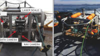


Aerospace & Defense Tech Briefs
Automated Atmospheric Correction of Nanosatellites Using Coincident Ocean Color Radiometer Data
Aerospace & Defense Tech Briefs
Industry Invited to Participate in AeroTech Aerospace and Defense Technical Program

Aerospace & Defense Tech Briefs
SAE International Extends Call for Abstracts, Seeks Submissions for AeroTech Conference
NASA Spinoff
Getting Water out of Snow with NASA Technology

Tech Briefs
Pulsed 2-Micron Laser Transmitter
Autonomous Vehicle Engineering
Continental's Lidar in a Flash


Automotive Engineering
Sensitive Subjects


Tech Briefs
Compact 3D LiDAR Imaging System
Overview
The document is the "Coastal Lidar and Radar Imaging System (CLARIS) Lidar Data Report: 2011 - 2017," authored by Nicholas J. Spore, Alexander D. Renaud, Ian W. Conery, and Katherine L. Brodie, and published by the U.S. Army Engineer Research and Development Center's Coastal and Hydraulics Laboratory. The report, finalized in July 2019, summarizes the lidar data collected along the northern Outer Banks of North Carolina over a six-year period.
The primary objective of the report is to present the available CLARIS data, which is crucial for understanding coastal dynamics, including shoreline changes, beach nourishment impacts, and environmental forcings affecting the region. The data collected through the CLARIS system provides high-resolution topographic information that is essential for coastal management and engineering applications.
The report highlights the importance of monitoring beach nourishment projects at multiple sites over time to assess their effectiveness and the influence of various environmental factors. It emphasizes that the upgrades made to the CLARIS system in 2017 enhance its capability to capture the evolution of coastal features at a regional scale, allowing for more comprehensive analysis and understanding of coastal processes.
In addition to summarizing the data collected, the report outlines the next steps for future research and data collection efforts. It indicates that subsequent reports will build on the findings of this document, focusing on changes observed with the modified CLARIS system and expanding the scale of data collection.
The report is approved for public release, ensuring that the findings and data are accessible to researchers, policymakers, and the public. It serves as a valuable resource for those involved in coastal research, management, and engineering, providing insights that can inform decision-making and enhance the resilience of coastal communities.
Overall, the CLARIS Lidar Data Report is a significant contribution to the understanding of coastal dynamics in the Outer Banks, offering a detailed overview of the data collected and its implications for future coastal management strategies.
Top Stories
NewsRF & Microwave Electronics
![]() Microvision Aquires Luminar, Plans Relationship Restoration, Multi-industry Push
Microvision Aquires Luminar, Plans Relationship Restoration, Multi-industry Push
INSIDERAerospace
![]() A Next Generation Helmet System for Navy Pilots
A Next Generation Helmet System for Navy Pilots
INSIDERDesign
![]() New Raytheon and Lockheed Martin Agreements Expand Missile Defense Production
New Raytheon and Lockheed Martin Agreements Expand Missile Defense Production
INSIDERMaterials
![]() How Airbus is Using w-DED to 3D Print Larger Titanium Airplane Parts
How Airbus is Using w-DED to 3D Print Larger Titanium Airplane Parts
NewsPower
![]() Ford Announces 48-Volt Architecture for Future Electric Truck
Ford Announces 48-Volt Architecture for Future Electric Truck
ArticlesAR/AI
Webcasts
Electronics & Computers
![]() Cooling a New Generation of Aerospace and Defense Embedded...
Cooling a New Generation of Aerospace and Defense Embedded...
Automotive
![]() Battery Abuse Testing: Pushing to Failure
Battery Abuse Testing: Pushing to Failure
Power
![]() A FREE Two-Day Event Dedicated to Connected Mobility
A FREE Two-Day Event Dedicated to Connected Mobility
Unmanned Systems
![]() Quiet, Please: NVH Improvement Opportunities in the Early Design Cycle
Quiet, Please: NVH Improvement Opportunities in the Early Design Cycle
Automotive
![]() Advantages of Smart Power Distribution Unit Design for Automotive &...
Advantages of Smart Power Distribution Unit Design for Automotive &...
Energy
![]() Sesame Solar's Nanogrid Tech Promises Major Gains in Drone Endurance
Sesame Solar's Nanogrid Tech Promises Major Gains in Drone Endurance