


Modeling Space-Based Intelligence, Surveillance, and Reconnaissance (ISR) in Combat Simulations
An analysis of the development of methodologies for representing the performance of commercial, national, and military space and low-earth-orbit assets and their impact on joint operations with a test implementation within the Framework for Capability-based Tactical Analysis Libraries and Simulations (FRACTALS).
During the 2021 Modeling and Simulation (M&S) Gap Forum, space intelligence, surveillance, and reconnaissance (ISR) modeling was identified as a current/near-future modeling gap. The U.S. Army Combat Capabilities Development Command (DEVCOM) Analysis Center (DAC) submitted an Army M&S Enterprise Capability Gap white paper (Harclerode, 2021) describing a course of action to help fill this gap. The Army Modeling and Simulation Office has funded DAC to develop methodologies for representing performance of commercial, national, and military space and low-earth- orbit assets and their impact on joint operations with a test implementation within the Framework for Capability-based Tactical Analysis Libraries and Simulations (FRACTALS).
FRACTALS is a DAC-developed simulation framework that provides the generic architectural “building blocks” to model, simulate, and assess performance of ISR systems in tactical-level missions and tasks. FRACTALS serves as a testbed for the various ISR performance methodologies developed at DAC to be incorporated into Force on Force simulations via methodology documentation and/or data. FRACTALS also serves as an analytical tool within DAC to execute performance analysis comparisons of ISR systems in tactical settings.
This effort requires some level of representation of satellite vehicles (altitude, trajectory, and kinematics), sensor payloads (electro-optical [EO], IR, synthetic aperture radar, and signals intelligence), networks, control systems, ground stations (timeline, communications, processing, exploitation, and dissemination), end users, and the processes and behaviors that connect them. The research describes some of the groundwork that DAC has performed to support this effort with a focus on visible-band camera imagery.
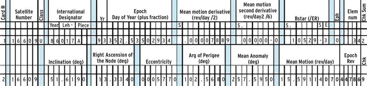
FRACTALS represents the orbital location of satellites through use of the Simplified General Perturbations 4 (SGP4) algorithm and the Two-Line Element (TLE) Set. The TLE Set contains the orbital characteristics of a satellite at a single moment in time, and the SGP4 algorithm will extrapolate the satellite's orbital location at a specific time in the future using the TLE set. Errors in orbital location will increase as the length of time between the TLE set and the extrapolation increases.
Up-to-date TLE sets for commercial satellites such as the one shown in Figure 1 can be obtained from a variety of sources. With the SGP4 algorithm and TLE sets, FRACTALS can predict the timing, duration, and resolution for satellite coverage of an area of interest on the ground.
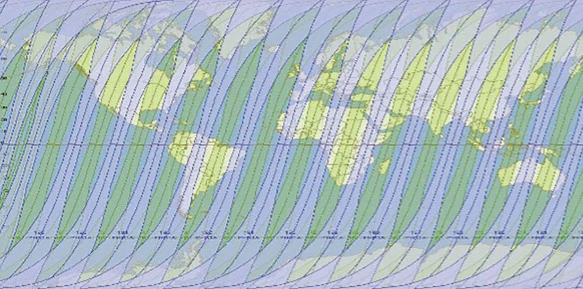
Coverage and revisit rate (how much of the earth you can see and how often) are two defining features of satellite constellations. Figure 2, extracted from the Pléiades Imagery User Guide (ASTRIUM, 2012), shows the global coverage available from two satellites. Using both satellites with view angles within ±30°, the revisit rate is 1.3 days or better above 40° latitude and 1.7 days at the equator. With view angles within ±45°, daily revisits are possible. A nadir view has a view angle of 0° and is looking straight down.
This work was done by John Mazz for the DEVCOM Analysis Center. For more information, download the Technical Support Package (free white paper)from the link below.
This Brief includes a Technical Support Package (TSP).
Modeling Space-Based Intelligence, Surveillance, and Reconnaissance (ISR) in Combat Simulations
(reference ARL-0247) is currently available for download from the TSP library.
Don't have an account?
More From SAE Media Group
Aerospace & Defense Tech Briefs
New Zealand and LeoLabs Establish the First Low-Earth Orbit Regulatory Platform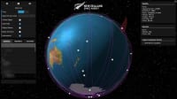
Aerospace & Defense Tech Briefs
Impact of Satellite Intelligence, Surveillance and Reconnaissance on Modern Naval Operations
Aerospace & Defense Tech Briefs
Lockheed Martin’s “Non-Operational” Space Fence Detects Indian Anti-Satellite Operations While Still in Test Mode
Aerospace & Defense Tech Briefs
Adding Context to Full-Motion Video for Improved Surveillance and Situational Awareness
Tech Briefs
Imaging Space Debris in High Resolution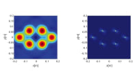
Aerospace & Defense Tech Briefs
Five Missile-Tracking Satellites Launched
Aerospace & Defense Tech Briefs
Optimal UAS Assignments and Trajectories for Persistent Surveillance and Data Collection from a Wireless Sensor Network
Aerospace INSIDER
Aitech’s New Palm-Sized Satellite Enables Space-Based AI Processing
Aerospace & Defense Tech Briefs
Industry Invited to Participate in AeroTech Aerospace and Defense Technical Program
Aerospace & Defense Tech Briefs
CAM Software
Aerospace & Defense Tech Briefs
Integrated Underwater Security System
Tech Briefs
Robust Bus Systems for CubeSats
Aerospace & Defense Tech Briefs
Cellular Satellites: Joint Communications with Integrated Acquisition
Aerospace & Defense Tech Briefs
Armored Vehicle Mission Management System
Aerospace & Defense Tech Briefs
Automated Atmospheric Correction of Nanosatellites Using Coincident Ocean Color Radiometer Data
Aerospace & Defense Tech Briefs
New Satellite Connectivity for Air Force Research Aircraft
Aerospace & Defense Tech Briefs
Simulation Tools Prevent Signal Interference on Spacecraft
Aerospace & Defense Tech Briefs
Nano-UAV Systems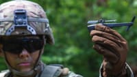
Aerospace & Defense Tech Briefs
A New Network Design for the “Internet from Space”
Aerospace & Defense Tech Briefs
Synthetic Aperture Radar Satellites for UK Defense
Aerospace & Defense Tech Briefs
Reconfigurable Radio Tracks Flights Worldwide
Aerospace & Defense Tech Briefs
Tactical Data Link Software
Aerospace & Defense Tech Briefs
Fully Autonomous Unmanned Vehicles
Aerospace & Defense Tech Briefs
Pathfinder Radar ISR and SAR Systems: Tactical Eyes for the Warfighter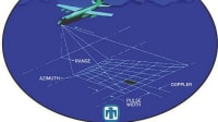

Automotive Engineering
OneWeb Ramps up Satellite Production with New Round of Funding
Tech Briefs
Lunar Surface Navigation System
Aerospace & Defense Tech Briefs
Thrust in Space - The Nuances of Thruster Valve Design
Aerospace & Defense Tech Briefs
SaraniaSat Wins $5M NASA InVEST Contract for Hyperspectral Thermal Imager
Defense INSIDER
Next-Generation Polar is Indispensable in Highly Contested Space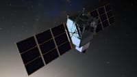
Overview
The technical report titled "Modeling Space-Based Intelligence, Surveillance, and Reconnaissance (ISR) in Combat Simulations," authored by John Mazz and published by the DEVCOM Analysis Center, focuses on developing methodologies to represent the performance of various space-based ISR assets in military combat simulations. The report is part of an effort to enhance the Army's capabilities in Multi-Domain Operations by integrating satellite imagery and data into combat scenarios.
The report outlines the use of the Framework for Capability-based Tactical Analysis Libraries and Simulations (FRACTALS) as a test-bed for methodology development. It emphasizes the importance of commercial, national, and military satellite constellations that provide high-resolution imagery, specifically targeting resolutions of 1 meter or better. The methodologies discussed include the Simplified General Perturbations 4 (SGP4) algorithm, which is utilized to predict the orbital paths of satellites, thereby allowing for accurate modeling of satellite movements and their implications for ISR operations.
Key components of the methodology include satellite positioning, global coverage, collection methods, and the impact of factors such as sensor characteristics, slant range, and viewing angles on image resolution. The report also addresses the National Imagery Interpretability Rating Scale (NIIRS) and Ground Sample Distance (GSD) as metrics for evaluating image quality and interpretability.
Additionally, the report discusses the challenges posed by partial cloud cover on satellite imagery and presents methods for representing these effects in simulations. By incorporating these methodologies, the report aims to improve the fidelity of combat simulations, enabling military planners and operators to better understand the contributions of space-based ISR assets in joint operations.
In conclusion, the report serves as a foundational document for future research and development in the field of military simulations, highlighting the critical role of satellite imagery in enhancing situational awareness and decision-making in combat scenarios. The findings are intended to support the Army's ongoing efforts to leverage advanced technologies for improved operational effectiveness in multi-domain environments.
Top Stories
NewsSensors/Data Acquisition
![]() Microvision Aquires Luminar, Plans Relationship Restoration, Multi-industry Push
Microvision Aquires Luminar, Plans Relationship Restoration, Multi-industry Push
INSIDERRF & Microwave Electronics
![]() A Next Generation Helmet System for Navy Pilots
A Next Generation Helmet System for Navy Pilots
INSIDERWeapons Systems
![]() New Raytheon and Lockheed Martin Agreements Expand Missile Defense Production
New Raytheon and Lockheed Martin Agreements Expand Missile Defense Production
NewsAutomotive
![]() Ford Announces 48-Volt Architecture for Future Electric Truck
Ford Announces 48-Volt Architecture for Future Electric Truck
INSIDERAerospace
![]() Active Strake System Cuts Cruise Drag, Boosts Flight Efficiency
Active Strake System Cuts Cruise Drag, Boosts Flight Efficiency
ArticlesTransportation
Webcasts
Aerospace
![]() Cooling a New Generation of Aerospace and Defense Embedded...
Cooling a New Generation of Aerospace and Defense Embedded...
Energy
![]() Battery Abuse Testing: Pushing to Failure
Battery Abuse Testing: Pushing to Failure
Power
![]() A FREE Two-Day Event Dedicated to Connected Mobility
A FREE Two-Day Event Dedicated to Connected Mobility
Automotive
![]() Quiet, Please: NVH Improvement Opportunities in the Early Design Cycle
Quiet, Please: NVH Improvement Opportunities in the Early Design Cycle
Electronics & Computers
![]() Advantages of Smart Power Distribution Unit Design for Automotive &...
Advantages of Smart Power Distribution Unit Design for Automotive &...
Unmanned Systems
![]() Sesame Solar's Nanogrid Tech Promises Major Gains in Drone Endurance
Sesame Solar's Nanogrid Tech Promises Major Gains in Drone Endurance