


Power-Line UAV Modeling and Simulation
Computer program helps UAVs avoid collisions with overhead wires.
The Army Research Laboratory Power-Line Unmanned Aerial Vehicle (UAV) Modeling and Simulation (ARL-PLUMS) Software Tool allows a user to model, compute, and analyze the quasistatic electric and magnetic fields around alternating current (AC) power lines. ARL-PLUMS comes with an interactive graphical user interface (GUI), which accesses a compute engine to calculate these fields around these lines due to various ground and line geometries and load conditions. ARLPLUMS allows the user to rapidly define all significant model parameters and compute the electric and magnetic fields along a UAV path or in a cutting plane. In addition, a set of false-color plots can be created to show the time-varying nature of the fields as a movie. ARL-PLUMS also comes with an application programming interface (API) for accessing some of these features from MATLAB without using the GUI.

ARL-PLUMS uses a right-handed coordinate system. When seated at the computer and looking at the monitor, the positive x direction is out of the screen, toward the user; the positive y direction is to the right; and the positive z direction is up, toward the ceiling. The power lines run parallel to the x axis and positive current runs in the positive x direction. Sea level is always at z = 0 m, and all other geometry is referenced to this. An example 2-D power-line model created in ARL-PLUMS is shown in the figure. In this example, there is a single 3-phase circuit 20 m above the ground, and the wires are spaced 4.4 m apart.
Generally, the electric and magnetic fields around power lines are treated separately and independently as quasistatic entities. This is permissible because at typical power-line frequencies (50 or 60 Hz) or low (e.g., 3rd or 5th) harmonics, the corresponding electromagnetic wavelengths are 1,000–6,000 km. Only the behavior of the fields in the vicinity of the power lines is of interest. This is generally 0–10 km away, which is a fraction of these wavelengths. In this region, coupled electromagnetic effects (such as wave propagation) are negligible compared to the effects of the quasistatic sources, themselves.
In the quasistatic case, the voltages on the lines give rise to an electric field around the lines, and the currents on the lines give rise to a magnetic field around the lines. However, while the currents are the sources of the magnetic field, the voltages do not directly source the electric field. Instead, through capacitive coupling, the voltages induce linear charge densities on the lines and an image charge distribution on the ground, and this charge distribution is the actual source of the electric field. In either case, the total (measured) field at any point is the superposition of the constituent fields from each line source at that point.
Various combinations of the electric and magnetic fields, such as rms magnitudes, derivatives with respect to time and/or distance, ratios, and percent changes, can be used by a UAV to detect power lines. Each of these quantities has a specific structure around the lines, which can be exploited to determine how close to the lines the UAV is. No matter the direction of approach, the UAV will measure larger and larger fields as it moves closer and closer to the lines. Once the UAV has detected the lines, it can take action to avoid crashing into them.
This work was done by Ross N. Adelman and David M. Hull of the Army Research Laboratory. ARL-0192
This Brief includes a Technical Support Package (TSP).
US Army Research Laboratory Power-Line UAV Modeling and Simulation (ARL-PLUMS Ver 2.x)
(reference ARL-0192) is currently available for download from the TSP library.
Don't have an account?
More From SAE Media Group
Aerospace & Defense Tech Briefs
Unmanned Aerial Systems Electromagnetic Induction Sensor Development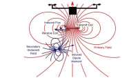
Aerospace & Defense Tech Briefs
ONR Short Pulse Research, Evaluation and non-SWaP Demonstration for C-sUAV Study
Aerospace & Defense Tech Briefs
Industry Invited to Participate in AeroTech Aerospace and Defense Technical Program
Aerospace & Defense Tech Briefs
Eyes In the Sky
Aerospace & Defense Tech Briefs
Effectiveness of Inter-Vehicle Communications and On-Board Processing for Close Unmanned Autonomous Vehicle Flight Formations
Aerospace & Defense Tech Briefs
Automatic Drone Detection System
Aerospace & Defense Tech Briefs
From DC to Daylight — How Innovations in Microwave Absorbers Shield the Warfighter
Tech Briefs
System Helps Drones Detect and Avoid Power Lines
Aerospace & Defense Tech Briefs
Powering Better Battlefield Drones
Tech Briefs
Facility Focus: Georgia Tech Research Institute
Aerospace & Defense Tech Briefs
Ghoul Tool: The Weapon-Mountable Counter UAS Transmitter
Aerospace & Defense Tech Briefs
Connectors Lighten the SWaP Burden in UAV/MUMT Aircraft Electronics
Aerospace & Defense Tech Briefs
Playing Defense — Uncertain Regulations Stall the Implementation of Counter-UAS Technology in The U.S.
Aerospace & Defense Tech Briefs
Drone Swarms: A Transformational Technology
Tech Briefs
Algorithms Improve Quadrotor Drone Performance
Aerospace & Defense Tech Briefs
Counter UAV System
Off-Highway Engineering
Addressing Electromagnetic Compatibility in the Context of Aircraft Electrification
Aerospace & Defense Tech Briefs
Autonomous “Wingman” Vehicles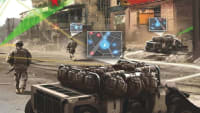
Aerospace & Defense Tech Briefs
XPONENTIAL 2019 – An AUVSI Experience
Tech Briefs
Insect-Sized Agile Drones
Aerospace & Defense Tech Briefs
Development of a Vision-Based Situational Awareness Capability for Unmanned Surface Vessels
Aerospace & Defense Tech Briefs
XPONENTIAL 2018 – An AUVSI Experience
Aerospace & Defense Tech Briefs
Bio-inspired Airborne Infrastructure Reconfiguration (BioAIR)
Aerospace & Defense Tech Briefs
Validation of Ubiquitous 2D Radar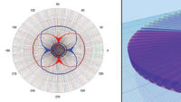
Aerospace & Defense Tech Briefs
Drone Control System
Aerospace & Defense Tech Briefs
Intelligent Parachute Rescue System
Aerospace & Defense Tech Briefs
Simulating Lightweight Vehicles Operating on Discrete Terrain
Aerospace & Defense Tech Briefs
Characterizing Motion Prediction in Small Autonomous Swarms
Aerospace & Defense Tech Briefs
DDDAMS-based Urban Surveillance and Crowd Control via UAVs and UGVs
Overview
The document titled "US Army Research Laboratory Power-Line UAV Modeling and Simulation (ARL-PLUMS Ver 2.x) Software Tool User Manual and Technical Report" serves as a comprehensive guide for users of the ARL-PLUMS software, which is designed to model and simulate the interactions between Unmanned Aerial Vehicles (UAVs) and power lines. Authored by Ross N Adelman and David M Hull, the report is dated September 2015 and covers the period from June 2013 to August 2014.
The primary objective of ARL-PLUMS is to enhance the understanding of UAV operations in proximity to power lines, which is critical for ensuring safety and operational efficiency. The software tool allows users to simulate various scenarios involving UAVs and power line environments, providing insights into potential risks and operational challenges.
The document includes sections detailing the software's features, user interface, and operational guidelines. Users are directed to access help resources within the software, including modeling assumptions, user manuals, and an annotated bibliography related to ARL's research on power lines. This ensures that users can fully leverage the capabilities of the software while understanding the underlying assumptions and methodologies.
Additionally, the report emphasizes the importance of adhering to the guidelines for information collection and reporting, as mandated by the Department of Defense. It outlines the public reporting burden associated with the use of the software and provides contact information for feedback and suggestions regarding the software and its documentation.
The report is structured to facilitate ease of use, with clear instructions on navigating the software's menu bar and accessing various help features. It also includes disclaimers regarding the findings and the use of manufacturer or trade names, clarifying that the report does not constitute an official endorsement.
Overall, the ARL-PLUMS User Manual and Technical Report is a vital resource for military and research personnel involved in UAV operations near power lines, providing essential information for safe and effective mission planning and execution. The document is approved for public release, ensuring that the insights and tools developed can be utilized broadly within the relevant fields.
Top Stories
INSIDERManufacturing & Prototyping
![]() How Airbus is Using w-DED to 3D Print Larger Titanium Airplane Parts
How Airbus is Using w-DED to 3D Print Larger Titanium Airplane Parts
INSIDERManned Systems
![]() FAA to Replace Aging Network of Ground-Based Radars
FAA to Replace Aging Network of Ground-Based Radars
NewsTransportation
![]() CES 2026: Bosch is Ready to Bring AI to Your (Likely ICE-powered) Vehicle
CES 2026: Bosch is Ready to Bring AI to Your (Likely ICE-powered) Vehicle
NewsSoftware
![]() Accelerating Down the Road to Autonomy
Accelerating Down the Road to Autonomy
EditorialDesign
![]() DarkSky One Wants to Make the World a Darker Place
DarkSky One Wants to Make the World a Darker Place
INSIDERMaterials
![]() Can This Self-Healing Composite Make Airplane and Spacecraft Components Last...
Can This Self-Healing Composite Make Airplane and Spacecraft Components Last...
Webcasts
Defense
![]() How Sift's Unified Observability Platform Accelerates Drone Innovation
How Sift's Unified Observability Platform Accelerates Drone Innovation
Automotive
![]() E/E Architecture Redefined: Building Smarter, Safer, and Scalable...
E/E Architecture Redefined: Building Smarter, Safer, and Scalable...
Power
![]() Hydrogen Engines Are Heating Up for Heavy Duty
Hydrogen Engines Are Heating Up for Heavy Duty
Electronics & Computers
![]() Advantages of Smart Power Distribution Unit Design for Automotive...
Advantages of Smart Power Distribution Unit Design for Automotive...
Unmanned Systems
![]() Quiet, Please: NVH Improvement Opportunities in the Early Design...
Quiet, Please: NVH Improvement Opportunities in the Early Design...