


Revolutionizing the Waves: A Breakthrough in Surf Observation Technology for Sailors and Marines
A team of Army and Navy scientists and engineers have developed a real-time sensing technology for deciding whether conditions are suitable for landing troops on enemy shores.
Imagine being entrusted with the vital responsibility of deciding whether conditions are suitable for landing troops on enemy shores, using nothing more than a ruler and tennis ball.
It sounds like a scene from a film, yet this is the reality for warfighters who rely on such basic tools to authorize troop movements from vessel to shore — employing eyesight observations to estimate wave height, a ruler to measure water depth and sometimes a tennis ball to determine current wave speed.
To improve this antiquated, time-consuming process, the Office of Naval Research (ONR) Global TechSolutions program — which sponsors the development of rapid prototype solutions based on direct requests from Sailors and Marines — worked with scientists and engineers from the Naval Research Laboratory (NRL) and the U.S. Army’s Engineering Research and Development Center (ERDC) to create the latest advancement in surf observation (SUROB) technology.
SUROB was among many innovations recently demonstrated at the Technical Concept Experiment (TCE) 24.2 held at Marine Corps Base Camp Pendleton, California.
Under the sponsorship of Dr. Joong Kim, a program officer in ONR’s Ocean Battlespace Sensing Department, and in collaboration with I Marine Expeditionary Force (MEF), the event showcased ONR-sponsored technologies to enhance Marine Corps capabilities in amphibious operations — including explosive hazard defeat/mine countermeasures as well as intelligence, surveillance and reconnaissance.
“This hands-on testing not only facilitates crucial feedback, but also fosters the integration of innovative solutions into operational environments, ultimately advancing the effectiveness of the Marine Corps mission,” said Kim.
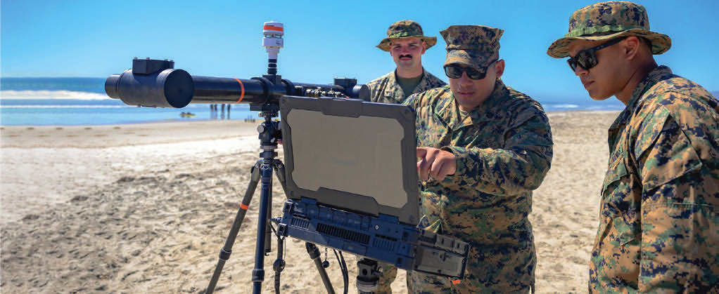
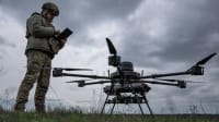
An essential part of the TechSolutions SUROB solution is the NRL-developed LittoralLens system and the ERDC-developed Littoral Imaging Software (LIS) for real time sensing of the environment. LittoralLens is a compact, easy-to-use stereoscopic camera system for shore and LIS is an unmanned aerial system, and both enable Marines to automatically measure water flow and wave patterns along coastlines.
“Now a warfighter can set up a stereoscopic camera on a tripod and let it collect measurements for as long as they need — or launch a small drone that can hover over the beach and take imagery,” said Jason Payne, TechSolutions director.
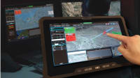
Equally as important is the fusion of this data for display on an Android Team Awareness Kit (ATAK) tablet, which is standard issue for Marines, ensuring that this new technological advancement would be compatible from the start.
“This sensor information is combined with existing environmental forecasts based on historic satellite images of the shoreline to calculate a Modified Surf Index score, which determines whether amphibious movement is safe or not. This score is then displayed on the ATAK tablet,” said Payne. “Ultimately, creating a more accurate, more precise and more repeatable measurement for Marines.”
Lt. Col. Joseph Murphy, head of the Ground Combat Element branch at the Marine Corps Warfighting Lab (MCWL) and guiding the project for MCWL, stressed how successful the project has been and how TechSolutions can benefit the operational force.
“We recognize that a problem set like improving surf observation really fits the TechSolutions mold well,” said Murphy. “This new SUROB technology adds efficiency to the current processes for beach reconnaissance or modified surf index reporting, which is then utilized by maneuver units and commanders to decide where they want to conduct amphibious operations as well as risk assessment.”
Chief Warrant Officer 3 Joseph Lester, Meteorology and Oceanography (METOC) platoon commander for 1st Intelligence Battalion, was among the warfighters to test the tool.
“The METOC Marines at 1st Intelligence Battalion were very grateful to participate in the development of the LittoralLens, and refinement and tailoring of the Littoral Imaging Software. It was rewarding to see how much warfighter input was realized and implemented in a relatively short amount of time,” said Lester.
“The hope is that this technology is adopted and fully funded as a program of record so that it can be used to support amphibious operations,” Lester added.
This article was written by Cherish T. Gilmore, a contractor for the Office of Naval Research. For more information, visit here .
More From SAE Media Group
Aerospace INSIDER
New Anduril, Skydio Drones Start Field Testing in Romania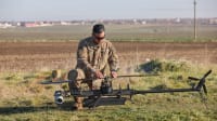

Aerospace INSIDER
Paris Air Show: New Aerospace Technologies, Updates and Research
Aerospace INSIDER
New Drones and Software Selected for DoD's Replicator 1.2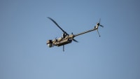
Aerospace & Defense Tech Briefs
Remotely Piloted Air Systems

Aerospace Manufacturing and Machining INSIDER
Counter UAS Systems Tested Against Swarms of 50 Drones in Latest Yuma Exercise
Defense INSIDER
Conference to Focus on Counter-Drone Technology
Defense INSIDER
Tiny UAS Could Be Warfighters’ Eyes in the Sky

Aerospace INSIDER
Short-Takeoff & Landing Capability to be Added to MQ-9B Aircraft
Aerospace & Defense Tech Briefs
Autonomous Collaborative Platform
Aerospace & Defense Tech Briefs
101st Combat Aviation Brigade Makes History with First MUOS Connectivity in a Helicopter
Aerospace & Defense Tech Briefs
Amphibious Combat Vehicle C4 UAS
Aerospace Manufacturing and Machining INSIDER
A New AI-Piloted VTOL Fighter Jet for Contested Environments

Aerospace INSIDER
Honeywell Launches New System to Counter Drone Swarms
Aerospace INSIDER
BAE Systems Acquires Developer of Electric Heavy Lift Quadcopters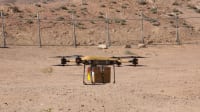

Aerospace & Defense Tech Briefs
Impact of Satellite Intelligence, Surveillance and Reconnaissance on Modern Naval Operations

Aerospace INSIDER
Navy Completes 73-Hour Nonstop Flight of Solar-Powered UAS

Aerospace INSIDER
New Commercial Drones and Components Added to Blue UAS Framework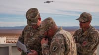
Aerospace & Defense Tech Briefs
Human-Focused Research Aims to Enhance UAS Effectiveness, Readiness
Top Stories
NewsSensors/Data Acquisition
![]() Microvision Aquires Luminar, Plans Relationship Restoration, Multi-industry Push
Microvision Aquires Luminar, Plans Relationship Restoration, Multi-industry Push
INSIDERRF & Microwave Electronics
![]() A Next Generation Helmet System for Navy Pilots
A Next Generation Helmet System for Navy Pilots
INSIDERWeapons Systems
![]() New Raytheon and Lockheed Martin Agreements Expand Missile Defense Production
New Raytheon and Lockheed Martin Agreements Expand Missile Defense Production
NewsAutomotive
![]() Ford Announces 48-Volt Architecture for Future Electric Truck
Ford Announces 48-Volt Architecture for Future Electric Truck
INSIDERAerospace
![]() Active Strake System Cuts Cruise Drag, Boosts Flight Efficiency
Active Strake System Cuts Cruise Drag, Boosts Flight Efficiency
ArticlesTransportation
Webcasts
Aerospace
![]() Cooling a New Generation of Aerospace and Defense Embedded...
Cooling a New Generation of Aerospace and Defense Embedded...
Energy
![]() Battery Abuse Testing: Pushing to Failure
Battery Abuse Testing: Pushing to Failure
Power
![]() A FREE Two-Day Event Dedicated to Connected Mobility
A FREE Two-Day Event Dedicated to Connected Mobility
Automotive
![]() Quiet, Please: NVH Improvement Opportunities in the Early Design Cycle
Quiet, Please: NVH Improvement Opportunities in the Early Design Cycle
Electronics & Computers
![]() Advantages of Smart Power Distribution Unit Design for Automotive &...
Advantages of Smart Power Distribution Unit Design for Automotive &...
Unmanned Systems
![]() Sesame Solar's Nanogrid Tech Promises Major Gains in Drone Endurance
Sesame Solar's Nanogrid Tech Promises Major Gains in Drone Endurance