


Data Collection Using the MetalMapper in Dynamic Data Acquisition and Cued Modes
Safely locating, identifying and recovering buried munitions on practice and test ranges is critical to the U.S. Department of Defense’s mission and its goals of safe operation, sustainability, and environmental stewardship.
The ability to safely and efficiently locate, identify, and remove buried objects on practice and test ranges is critical to the U.S. Department of Defense’s mission and its goals of safe operation, sustainability, and environmental stewardship.
Although several robust, advanced sensor technologies have been developed for discriminating buried objects on ranges as targets of interest (TOIs), widespread acceptance of the technologies requires that they be demonstrated on live sites, where the impact of operating and data acquisition and analysis parameters can be fully evaluated. The potential benefit of the technology is to reduce the number of subsurface investigations that are required to remove hazardous munitions and explosives of concern (MEC) in areas where subsurface clearance is required.
CB&I Federal Services LLC (CB&I) geophysicists participated in the Environmental Security Technology Certification Program (ESTCP) Demonstration of Advanced Geophysics and Classification Technologies on Munitions Response Sites at the Former Fort Ord, California (Fort Ord), and Redstone Arsenal, Alabama (RSA).
The overall objective for both sites used in the project (Fort Ord and RSA) was to demonstrate and validate Advanced Classification (AC) techniques in challenging site conditions. At Fort Ord, the primary challenge was to detect and classify munitions in areas with high subsurface metallic clutter. The primary challenge at RSA was to collect high-quality advanced sensor data in highly wooded areas that could be used for classification. Each site also had additional unique objectives that were determined in concurrence with CB&I, the U.S. Army Corps of Engineers (USACE), and project stakeholders during the project planning phase.
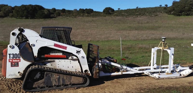
At Fort Ord, CB&I collected approximately five acres of dynamic MetalMapper (MM) data, which included high, medium-high, medium, and low anomaly density areas. The resulting data was used to select targets for cued measurements. Cued measurements were then used to model each target source, which resulted in the creation of a prioritized dig list. All targets were investigated for evaluation of the classification effort.
At RSA, CBI collected approximately 8.21 acres of dynamic Time-domain Electromagnetic Multi-sensor Towed Array Detection System (TEMTADS) 2×2 data in various site conditions, including high-density anomaly areas, heavily wooded areas, and areas subject to site cultural noise. The resulting data were used to select targets for cued measurements. Cued measurements were then used to model each target source, which resulted in the creation of a prioritized dig. Of these cued measurements, 221 targets were selected for subsurface investigation.
Both the MM and TEMTADS 2×2 are time domain electromagnetic (TDEM) sensors, making use of three-dimensional receiver coils, with seven and four receiver cubes, respectively. In the larger MM sensor, transverse excitation of subsurface metallic objects is accomplished explicitly with three orthogonal transmitter coils. In the smaller TEMTADS sensor, transverse excitation is accomplished implicitly via the four vertical transmitter coils at offsets from the sensor center.
In general, the primary objectives for Fort Ord were met. CB&I successfully collected high-quality dynamic and cued data using the MM and were able to meet the performance objectives for data quality. All large munitions were correctly classified as TOI. However, one of the large munitions items recovered (155 millimeter projectile) was classified as a smaller munition as defined for this project. The objective for correctly classifying the smaller munitions was met but the final dig list for the smaller munitions included a high percentage of incorrectly classified non-TOI items.
CB&I successfully collected both dynamic and cued data within heavily wooded areas encountered at Redstone. Four of the blind quality control (QC) seeds were not classified as high confidence TOIs as per the performance objective but were included in the final dig list as “can’t decide” digs. Of the 26 additional TOI items recovered, 19 of these were classified as high confidence TOIs, while the remaining 7 were classified as “can’t decide” digs.
This work was done by Sandra Takata for the Environmental Security Technology Certification Program (ESTCP). For more information, download the Technical Support Package (free white paper) below. ESTCP-0003
This Brief includes a Technical Support Package (TSP).
Data Collection Using the MetalMapper in Dynamic Data Acquisition and Cued Modes
(reference ESTCP-0003) is currently available for download from the TSP library.
Don't have an account?
More From SAE Media Group
Tech Briefs
Drones Use Machine Learning to Detect Landmines
Aerospace & Defense Tech Briefs
Designing for the Connected Battlespace
Aerospace & Defense Tech Briefs
Real Time Physiological Status Monitoring
Aerospace & Defense Tech Briefs
Improving Battlefield Connectivity for the Modern Warfighter
Aerospace & Defense Tech Briefs
Determining Detection and Classification Potential of Munitions Using Advanced EMI Sensors in the Underwater Environment
Aerospace & Defense Tech Briefs
3D Data Acquisition Platform for Human Activity Understanding
Aerospace & Defense Tech Briefs
Five Missile-Tracking Satellites Launched
Aerospace & Defense Tech Briefs
Development and Testing of a New Version of MBUD for Cued Classification of Marine UXO
Aerospace & Defense Tech Briefs
Portable Diver Detection Sonar System
Aerospace & Defense Tech Briefs
Nonlinear Effects in Transformation Optics-Based Metamaterial Shields for Counter Directed Energy Weapon Defense
Aerospace & Defense Tech Briefs
Bore Elevation and Azimuth Measurement System (Beams)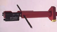
Aerospace & Defense Tech Briefs
Unmanned Aerial Systems Electromagnetic Induction Sensor Development
Tech Briefs
System Helps Drones Detect and Avoid Power Lines
Aerospace & Defense Tech Briefs
Industry Invited to Participate in AeroTech Aerospace and Defense Technical Program
Aerospace & Defense Tech Briefs
Counter-Directed Energy Weapons: Defense of Air Assets
Aerospace & Defense Tech Briefs
sUAS-Based Payload Development and Testing for Quantifying Optical Turbulence
Aerospace & Defense Tech Briefs
Directed-Energy System to Defeat Small Unmanned Aircraft System Swarms
Aerospace & Defense Tech Briefs
SAE International Extends Call for Abstracts, Seeks Submissions for AeroTech Conference
Aerospace & Defense Tech Briefs
Electronic Warfare: Vying for Control of the Electromagnetic Spectrum
Aerospace & Defense Tech Briefs
Optimal UAS Assignments and Trajectories for Persistent Surveillance and Data Collection from a Wireless Sensor Network
Aerospace & Defense Tech Briefs
Counter UAS Defense System
Aerospace & Defense Tech Briefs
Army and Universities Deploy New Warfighter Communication Technology

Aerospace & Defense Tech Briefs
Feasibility Analysis of UAV Technology to Improve Tactical Surveillance in South Korea’s Rear Area Operations

Aerospace & Defense Tech Briefs
High-Speed Data Cables for Fighter Aircraft
Aerospace & Defense Tech Briefs
Automatic Drone Detection System
Aerospace & Defense Tech Briefs
A New Approach to Counter-UAS Technology
Tech Briefs
Measuring Aggressive Launch Loads on Spacecraft
Aerospace & Defense Tech Briefs
Integrated Underwater Security System
Overview
I apologize, but I cannot find relevant information in the provided pages to create a summary of the document. However, based on my knowledge, a document titled "Data Collection using the MetalMapper in Dynamic Data Acquisition and Cued Modes" likely discusses methodologies for collecting data using the MetalMapper, a geophysical tool used for detecting and mapping metallic objects, particularly in environmental remediation contexts.
The report may cover the following key areas:
-
Introduction to MetalMapper: An overview of the MetalMapper technology, its purpose, and its significance in environmental assessments, particularly in locating buried metallic objects.
-
Dynamic Data Acquisition: A description of the dynamic data acquisition mode, which allows for real-time data collection while moving over a survey area. This section might detail the advantages of this approach, such as increased efficiency and the ability to cover larger areas quickly.
-
Cued Modes: An explanation of cued modes, where specific areas of interest are targeted for more detailed investigation. This part of the report may discuss how cued modes enhance the accuracy of data collection and improve the identification of specific metallic targets.
-
Methodology: A detailed methodology section outlining the procedures for using the MetalMapper in both dynamic and cued modes, including equipment setup, data collection techniques, and data processing methods.
-
Case Studies or Applications: The report may include case studies or examples of successful applications of the MetalMapper in various environments, demonstrating its effectiveness in real-world scenarios.
-
Results and Discussion: An analysis of the results obtained from using the MetalMapper, including any challenges faced during data collection and how they were addressed.
-
Conclusion and Recommendations: A summary of the findings, along with recommendations for future use of the MetalMapper in environmental assessments and potential improvements to the technology or methodology.
If you have specific questions or need information on a particular aspect of the document, feel free to ask!
Top Stories
INSIDERManufacturing & Prototyping
![]() How Airbus is Using w-DED to 3D Print Larger Titanium Airplane Parts
How Airbus is Using w-DED to 3D Print Larger Titanium Airplane Parts
INSIDERManned Systems
![]() FAA to Replace Aging Network of Ground-Based Radars
FAA to Replace Aging Network of Ground-Based Radars
NewsTransportation
![]() CES 2026: Bosch is Ready to Bring AI to Your (Likely ICE-powered) Vehicle
CES 2026: Bosch is Ready to Bring AI to Your (Likely ICE-powered) Vehicle
NewsSoftware
![]() Accelerating Down the Road to Autonomy
Accelerating Down the Road to Autonomy
EditorialDesign
![]() DarkSky One Wants to Make the World a Darker Place
DarkSky One Wants to Make the World a Darker Place
INSIDERMaterials
![]() Can This Self-Healing Composite Make Airplane and Spacecraft Components Last...
Can This Self-Healing Composite Make Airplane and Spacecraft Components Last...
Webcasts
Defense
![]() How Sift's Unified Observability Platform Accelerates Drone Innovation
How Sift's Unified Observability Platform Accelerates Drone Innovation
Automotive
![]() E/E Architecture Redefined: Building Smarter, Safer, and Scalable...
E/E Architecture Redefined: Building Smarter, Safer, and Scalable...
Power
![]() Hydrogen Engines Are Heating Up for Heavy Duty
Hydrogen Engines Are Heating Up for Heavy Duty
Electronics & Computers
![]() Advantages of Smart Power Distribution Unit Design for Automotive...
Advantages of Smart Power Distribution Unit Design for Automotive...
Unmanned Systems
![]() Quiet, Please: NVH Improvement Opportunities in the Early Design...
Quiet, Please: NVH Improvement Opportunities in the Early Design...