


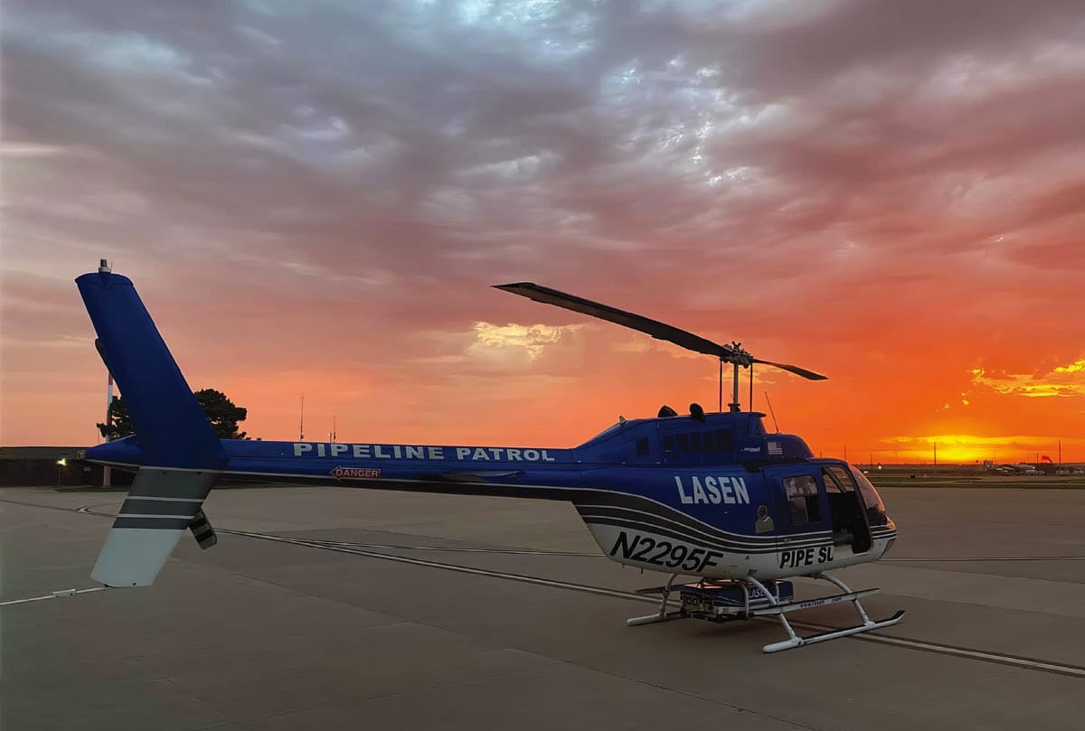
Airborne Inspection Sensor Evolves with LiDAR, Mid-IR and Artificial Intelligence
With funding from the US Departments of Transportation, Energy, Defense, and others, Airborne LiDAR Pipeline Inspection Sensor (ALPIS®) has evolved from a simple proof of concept model to a fully capable and successful commercial airborne pipeline inspection system. The ALPIS® system has undergone a long development period.
In 1989, a joint project was initiated with Phillips Petroleum to determine if a mobile truck-mounted mid-infrared (IR) laser system could be used to detect natural gas and other volatile organic compounds (VOC) in the field. One specific aspect of the project was to determine if the system could detect the presence of untapped oil and natural gas fields by sensing any VOC plumes escaping from the ground into the atmosphere.
In 1998 LaSen received funding from the U.S. Department of Transportation and U.S. Air Force to develop a tunable airborne differential absorption LiDAR sensor, “DIAL,” in the 3 – 5μm, mid-IR range. Next, in 2003, LaSen was invited to participate with the Edgewood Chemical and Biological Center (ECBC) to remotely discriminate between biological and non-biological aerosols. The sensor was very successful in detecting radiated anthrax and a variety of individual chemical species used in the bioagent fermentation process. LaSen developed two ground-based 10 Hz units and one 40 Hz helicopter-based prototype unit.
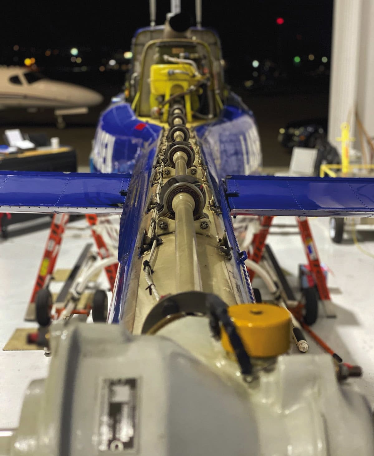
In 2004 the first airborne production prototype was assembled. The third generation ALPIS® unit was used to determine the best design, layout, and hardware to streamline and standardize the manufacture of future production units. It was also used to demonstrate the commercial capabilities of the helicopter-mounted ALPIS system and service to potential customers.
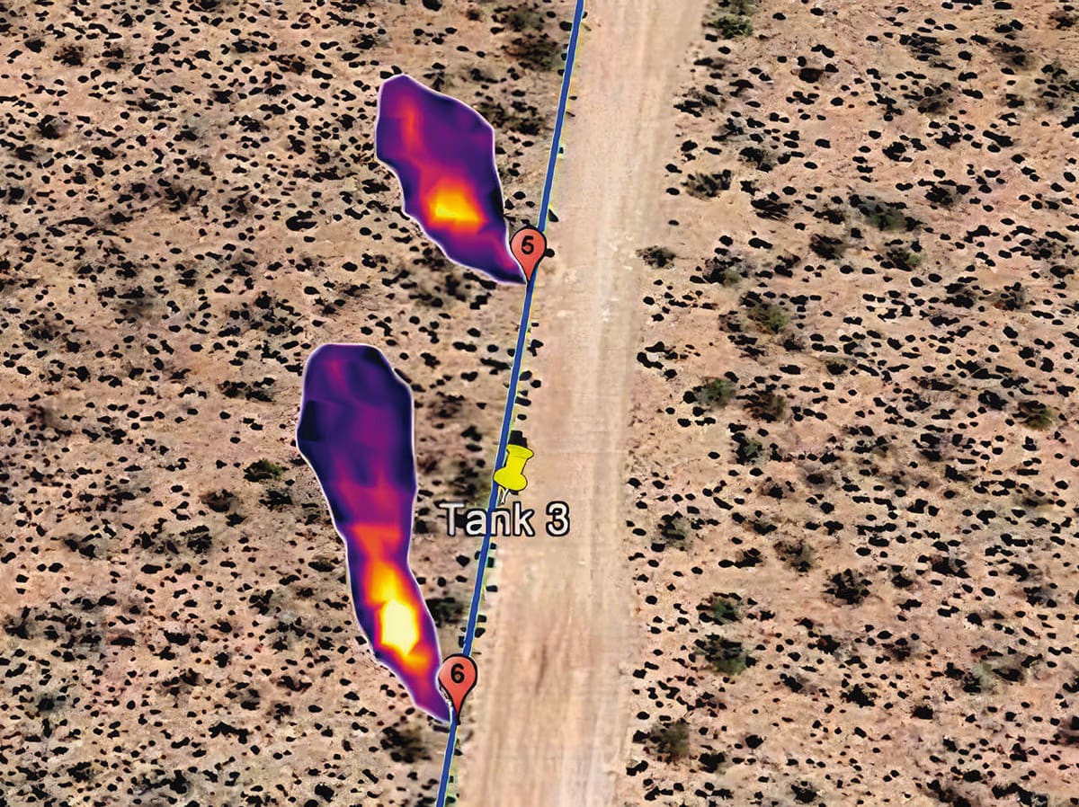
In 2005, the National Energy Technology Laboratory (NETL) invited LaSen to use its ALPIS® to evaluate airborne and ground-based detection sensors for abandoned wellheads in the gathering fields of Casper, Wyoming. ALPIS® was used in conjunction with Fugro Airborne Survey’s Midas 2 magnetometers airborne system to survey the Salt Creek oilfield near Casper, Wyoming. ALPIS was able to find several positive Methane leak indications, with leak sizes down to 4ppm at a flight altitude of 150 feet. In 2018 ALPIS was able to detect and differentiate water line leaks from fracking within ground water at the UTE Indian Reservation in Colorado.
Over the last 20 years LaSen’s sensor has quietly achieved many firsts and upgrades with its modular design. ALPIS® is the first mid-IR airborne laser sensor to be supplemental type certification (STC)-approved by the Federal Aviation Administration (FAA) getting its own STC number (SR00958DE). LaSen also received an FDA accession number (161029-000), certifying that the laser beam is eye-safe. A Department of Defense article published in March 2020, “A Nose for Trouble”, declared that LaSen has “the most advanced airborne aerial leak detection service on the market now serving industry, making our nation safer even as it’s helping to protect the environment.” ALPIS® routinely detects methane concentrations down to 5 parts per million-meter (ppm-m) or 5 standard cubic feet per hour (SCFH). These figures have been verified by third party blind testing at the Methane Emissions Technology Evaluation Center (METEC) at Colorado State University.
Since its commercialization, ALPIS® has flown over 650,000 miles of pipeline, detecting over 60,000 leak indications, preventing over 60 billion cubic feet of methane from escaping into the atmosphere. In 2023 alone, LaSen expects to complete inspections of over 80,000 miles of pipeline for its energy sector customers.
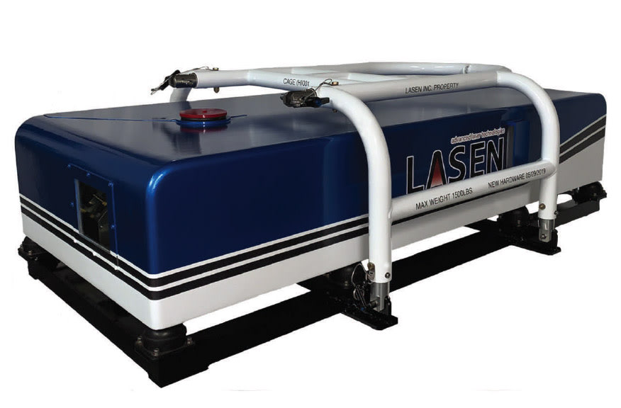
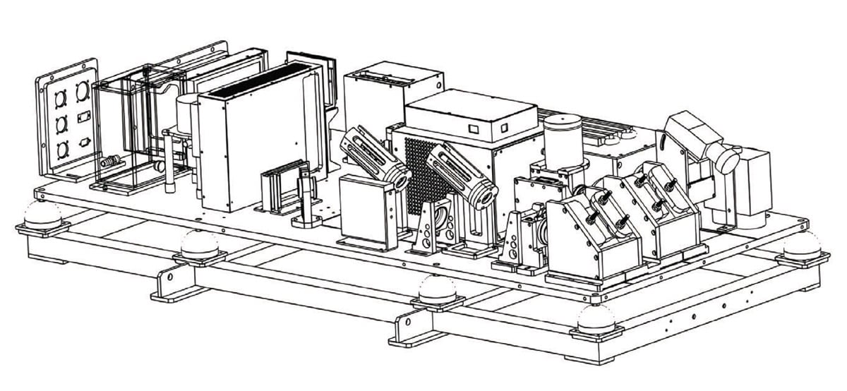
The internal OPO cavity laser and tuner was developed by LaSen and is tunable from 3.1-3.5 μm. This enables the sensor to detect methane, propane, butane, pentane, and other hydrocarbons. LaSen is developing a new laser tuner that will allow the onboard system to change the chemical absorptions line during flight operation to detect multiple hydrocarbons simultaneously. The absorption lines of methane in the mid-IR are several orders of magnitude greater than the near-IR.
The greatest problem associated with sensing atmospheric methane in mid-IR is atmospheric moisture. The absorption lines from water molecules are prevalent in the mid-IR and will intensify as relative humidity increases. To solve this problem LaSen has mapped out every water line between 3.1μm-3.5 μm. By decreasing the laser line width to one nanometer it’s possible to shoot between water absorption lines and allow the sensor to detect multiple gases in the mid-IR region without water interference.
This wavelength range is spectroscopically significant because it features numerous absorption lines associated with chemical bonds between hydrogen and carbon/oxygen/nitrogen. Therefore, operating in the mid-IR will provide 200 times the line strength as near-IR for detecting atmospheric gases, including methane.
Other major advancements in ALPIS® includes increasing the firing from 10 MHz up to 400 MHz today. We are also currently developing a 1 KHz laser system. The greater repetition rate allows for better data resolution for 2-D plume modeling and detection abilities. Currently, data used from the ALPIS® sensor can generate a GPS location of the leak indication with quantification identification of small, medium or large.
LaSen is currently developing a new urban atmospheric measurement technology that will support the need for enhanced atmospheric measurement systems in urban environments. The Mobile Atmospheric Gas Nonintrusive Urban Mapper (MAGNUM) will have a real-time active remote mid-IR laser system that is robust, low-powered, and tamper-resistant by being housed in a light-weight modular package attached inside a surface vehicle. The MAGNUM will provide nonintrusive leak detection and precision mapping of gas leaks with significant savings on the cost per mile and time compared to the current conventional in situ and near-IR leak detection services on the market today. The beam path and resulting laser footprint will be 75 square feet or more and will be able to cover the area from the ground to the height of an average one-story structure covering 360 degrees of the surrounding area.
MAGNUM will take the present advanced technology through to the next generation. The lightweight package can be outfitted initially to ground vehicles and eventually on to an unmanned aircraft. Additionally, the data processing software will feature a new supervised artificial intelligence (AI) algorithm trained with actual MAGNUM data. This algorithm will be able to automatically identify true positives and eliminate false positives with not only high accuracy, but also speed. By switching from the Bell 206 Jet Ranger helicopters to a mobile (vehicle) platform wherever practical, and using new AI processing software, the lidar operating and data processing cost will be decreased by more than 60 percent, allowing LaSen to pass these savings on to its customers.
This article was written by Phillip Padilla, Project Lead, LaSen Inc. For more information, visit here .
More From SAE Media Group
Autonomous Vehicle Engineering
Improving Lidar – or Defeating It
ADAS & Autonomous Vehicle Engineering
Making Sense of Next-Gen ADAS Sensing
Off-Highway Engineering
Veoneer Shows Its Latest Safety and AV Tech
Automotive Engineering
New R&D Boss Details RoboSense’s LiDAR Strategy
Autonomous Vehicle Engineering
Sensing Enters a New Era
Autonomous Vehicle Engineering
Special Delivery – by ‘Bot
Sensor Technology
Drones Spot Gas Leaks From the Sky
Automotive Engineering
Q&A: Owl AI Making Better ADAS Systems with Help from Drones
Sensor Technology
Artificial Intelligence in Cars — Inside the Brains
Automotive Engineering
Ford Releasing Comprehensive Dataset to Promote Autonomous R&D
Autonomous Vehicle Engineering
Mapping Canada — Centimeter by Centimeter
Autonomous Vehicle Engineering
New Roles for Lidar in Autonomy’s Lower Levels
ADAS & Autonomous Vehicle Engineering
AV Life After Argo AI
Photonics & Imaging Technology
This MEMS Scanning Mirror Could Solve LiDAR’s Expensive Autonomous Vehicle Challenges
Autonomous Vehicle Engineering
The ‘Buzz’ in Driverless Shuttling
Automotive Engineering
Designing and Assessing Vehicle Safety Functions with a Use Case Approach

Automotive Engineering
Valeo Debuts New Lidars, EV Tech at CES 2022
Automotive Engineering
Expanding ADAS Roles for Radar and Cameras
Sensor Technology
Better LIDAR in Autonomous Systems Starts with MEMS
Off-Highway Engineering
CES 2024: Aeva Launches 4D Lidar for SAE Level 4 Trucks
Autonomous Vehicle Engineering
Flash! Lidar’s Next Generation Arrives
Tech Briefs
A Step Toward More Accurate 3D Object Detection
ADAS & Autonomous Vehicle Engineering
Lidar Vs. Everybody in the Onboard Sensor Race

Autonomous Vehicle Engineering
Radar’s Evolving Role in ADAS and the AV Future
Autonomous Vehicle Engineering
'Boaring' in on Vehicle-To-Animal Road Safety

Tech Briefs INSIDER
Report from SPIE 2017: Drones Spot Gas Leaks from the Sky
Top Stories
INSIDERMaterials
![]() How Airbus is Using w-DED to 3D Print Larger Titanium Airplane Parts
How Airbus is Using w-DED to 3D Print Larger Titanium Airplane Parts
INSIDERAerospace
![]() FAA to Replace Aging Network of Ground-Based Radars
FAA to Replace Aging Network of Ground-Based Radars
NewsUnmanned Systems
![]() CES 2026: Bosch is Ready to Bring AI to Your (Likely ICE-powered) Vehicle
CES 2026: Bosch is Ready to Bring AI to Your (Likely ICE-powered) Vehicle
NewsSoftware
![]() Rewriting the Engineer’s Playbook: What OEMs Must Do to Spin the AI Flywheel
Rewriting the Engineer’s Playbook: What OEMs Must Do to Spin the AI Flywheel
Road ReadyTransportation
![]() 2026 Toyota RAV4 Review: All Hybrid, All the Time
2026 Toyota RAV4 Review: All Hybrid, All the Time
NewsSoftware
Webcasts
Automotive
![]() E/E Architecture Redefined: Building Smarter, Safer, and Scalable...
E/E Architecture Redefined: Building Smarter, Safer, and Scalable...
Transportation
![]() Hydrogen Engines Are Heating Up for Heavy Duty
Hydrogen Engines Are Heating Up for Heavy Duty
Automotive
![]() Advantages of Smart Power Distribution Unit Design for Automotive...
Advantages of Smart Power Distribution Unit Design for Automotive...
Automotive
![]() Quiet, Please: NVH Improvement Opportunities in the Early Design...
Quiet, Please: NVH Improvement Opportunities in the Early Design...
Power
![]() A FREE Two-Day Event Dedicated to Connected Mobility
A FREE Two-Day Event Dedicated to Connected Mobility
Power
![]() Powering America’s EV Future: Connect, Collaborate, Innovate
Powering America’s EV Future: Connect, Collaborate, Innovate