


NASA Sees How Drones Fight California Wildfires
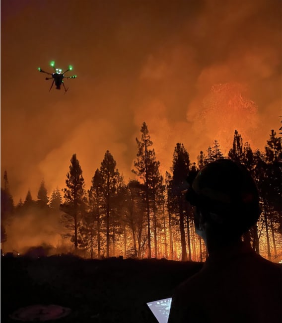
NASA’s Scalable Traffic Management for Emergency Response Operations, or STEReO , project is designing software and communication tools to help disaster responders work more safely and efficiently. Part of their approach is to scale up the use of unmanned aircraft systems (UAS) or drones.
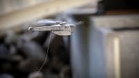
Drones are good for capturing thermal images of the landscape below. The heat signatures obtained can help determine where firefighters should establish fire-containment lines, dug either by bulldozer or by hand.
On the frontlines of the California wildfires, a drone was sent to look for any traces of fire down a steep gully. The thermal data it collected helped decide whether crews could safely attempt to hold the fire there, or if they should work from the next ridgeline, even if it meant losing more acres to the flames.
More From SAE Media Group
Aerospace INSIDER
Drones for Disaster Response

NASA Spinoff
From Shark Searches to Space Tours
Aerospace & Defense Tech Briefs
Low Cost Air Traffic Control for Drones

Aerospace INSIDER
NASA UAV Flies Alone in Public Airspace
Aerospace INSIDER
GA-ASI Announces Gray Eagle 25M for Multi-Domain Operations
Aerospace & Defense Tech Briefs
Autonomous Collaborative Platform
Aerospace & Defense Tech Briefs
New Method to Measure Wind Speed Could Unlock Drones’ Potential

Aerospace & Defense Tech Briefs
MUSHER Demonstrates Manned-Unmanned Aircraft Teaming Applications
Aerospace INSIDER
System Identifies, Tracks, and Captures Enemy Drones
Aerospace INSIDER
NASA Tests Could Lead to FAA Integration of UAVs
NASA Spinoff
Eagle Eyes in Treacherous Skies
Motion Design INSIDER
AI-Powered Vision System Helps Drones Navigate Safely
Aerospace INSIDER
Crashing Into Safe Autonomous Flight
Aerospace INSIDER
NASA Technologies Improve Drone Design
Aerospace & Defense Tech Briefs
Remotely Piloted Aircraft
NASA Spinoff
Swarming Technology Lets Drones Work as a Team
Aerospace & Defense Tech Briefs
Effectiveness of Inter-Vehicle Communications and On-Board Processing for Close Unmanned Autonomous Vehicle Flight Formations
Aerospace INSIDER
NASA Tests Technologies to Increase Drone Uses
Aerospace INSIDER
XQ-67A's First Flight Shows 'Genus' Approach to Aircraft Design
Aerospace & Defense Tech Briefs
Assessment of Noncommercial Icing Prediction Capabilities for Army Applications
Aerospace & Defense Tech Briefs
VISTA X-62

Podcasts
A.I. in the Air
Aerospace & Defense Tech Briefs
AI Algorithms Fly Valkyrie XQ-58A
Aerospace & Defense Tech Briefs
Intelligent Parachute Rescue System
Top Stories
INSIDERManufacturing & Prototyping
![]() How Airbus is Using w-DED to 3D Print Larger Titanium Airplane Parts
How Airbus is Using w-DED to 3D Print Larger Titanium Airplane Parts
INSIDERManned Systems
![]() FAA to Replace Aging Network of Ground-Based Radars
FAA to Replace Aging Network of Ground-Based Radars
NewsTransportation
![]() CES 2026: Bosch is Ready to Bring AI to Your (Likely ICE-powered) Vehicle
CES 2026: Bosch is Ready to Bring AI to Your (Likely ICE-powered) Vehicle
NewsSoftware
![]() Accelerating Down the Road to Autonomy
Accelerating Down the Road to Autonomy
EditorialDesign
![]() DarkSky One Wants to Make the World a Darker Place
DarkSky One Wants to Make the World a Darker Place
INSIDERMaterials
![]() Can This Self-Healing Composite Make Airplane and Spacecraft Components Last...
Can This Self-Healing Composite Make Airplane and Spacecraft Components Last...
Webcasts
Defense
![]() How Sift's Unified Observability Platform Accelerates Drone Innovation
How Sift's Unified Observability Platform Accelerates Drone Innovation
Automotive
![]() E/E Architecture Redefined: Building Smarter, Safer, and Scalable...
E/E Architecture Redefined: Building Smarter, Safer, and Scalable...
Power
![]() Hydrogen Engines Are Heating Up for Heavy Duty
Hydrogen Engines Are Heating Up for Heavy Duty
Electronics & Computers
![]() Advantages of Smart Power Distribution Unit Design for Automotive...
Advantages of Smart Power Distribution Unit Design for Automotive...
Unmanned Systems
![]() Quiet, Please: NVH Improvement Opportunities in the Early Design...
Quiet, Please: NVH Improvement Opportunities in the Early Design...