


Calibrated Long-Wave Infrared (LWIR) Thermal and Polarimetric Imagery of Small Unmanned Aerial Vehicles (UAVs) and Birds
Producing a set of well-calibrated imagery, both conventional LWIR thermal (watts/cm 2-sr) and its corresponding polarimetric imagery (percent radiance polarized), helps evaluate the ability to distinguish between small UAVs and birds of similar size and dimensions.
Currently, agencies within the Department of Defense (DOD) and the private sector are trying to develop techniques capable of detecting the presence of small unmanned aerial vehicles (UAVs) at ranges on the order of 1–5 km. Often complicating this effort is the presence of small birds of similar dimensions that are frequently mistaken to be small UAVs when imaged using various methodologies, such as visible, short-wave infrared (SWIR) and thermal imaging.
Initially, research was limited to long-wave infrared (LWIR) thermal imaging that, in theory, should be effective for both day-and night-time operation. The goal was to record a preliminary set of calibrated radiometric and polarimetric images in which both small UAVs and birds were present in the scene. Targets (i.e., UAV and/or birds) within each image were segmented and regions of interest (ROI) were generated by tracing a circumference around the object. Pixel values were then averaged to yield both a radiometric value (watts/cm2-sr) and a corresponding polarimetric value (percentage linearly polarized) in order to quantify similarities and differences between “generic” bird and UAV signatures.
Although LWIR radiometric thermal signature capture and analysis techniques are very mature and well understood, thermal polarimetric methods and analysis are less developed. For the polarimetric analysis presented here, the well-accepted Stokes image methodology that effectively yields the percentage of the overall radiance emitted/reflected from the object that is linearly polarized will be used.
The most common approach for measuring the polarization state for emitted or reflected light is to measure the Stokes parameters: S0, S1, S2, and S3. For imaging applications these Stokes parameters are determined on a pixel-by-pixel basis in order to reconstruct a 2-D image. The Stokes parameters are determined by measuring the intensity of radiance that is projected through a polarizer/wave-plate pair that are oriented at various angles in order to measure the intensity of a particular state..
The Stokes images S0, S1, S2, and S3 are defined by Eqs. 1, 2, 3, 4:
S1 = I(0) – I(90) (w/sr-cm2), (1)
S2 = I(+45) – I(–45) (w/sr-cm2), (2)
S3 = I(R) – I(L) (w/sr-cm2), (3)
where I(0), I(90), I(+45), and I(–45) represent the measured radiant intensity of the linear states (measured relative to the vertical), at angles 0°, 90°, +45°, and –45°, respectively, and I(R) and I(L) represent right- and left-handed circularly polarized radiant states. The total radiance, S0, image (often thought of as just the intensity image) is defined as,
![]() (4)
(4)
and the degree-of-total-polarization parameter/image is defined as,
![]()
![]() (5)
(5)
However, for most applications that involve remote passive polarimetric imaging in the thermal IR, S3 is very small and rarely measurable and thus taken to be approximately zero. As a result, Eq. 5 is reduced to the more common degree-of- linear-polarization (DoLP) parameter/image and is defined as,
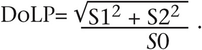 (6)
(6)
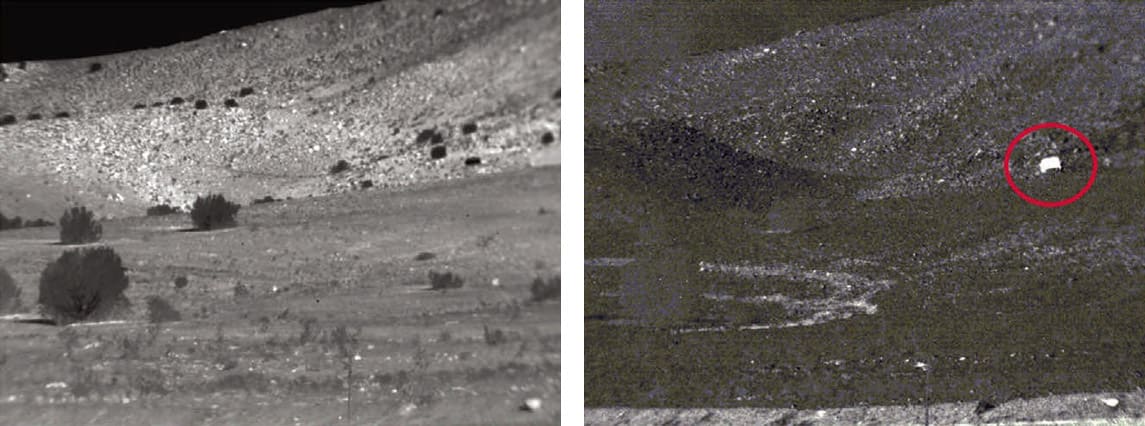
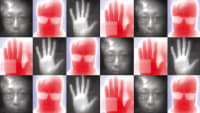
There are a variety of optical approaches/methods implemented in various polarimetric camera designs appropriate for polarization state filtering and analysis in the thermal IR. Examples include division-of-time approach, which uses a spinning-achromatic-retarder (SAR) arrangement, a division-of-amplitude (DoA) in which a polarized beam-splitting-plate is used to project different polarization states of the same scene onto one, two, or more focal-plane-arrays (FPA), and the division-of-focal-plane (DoFP) design in which micro-polarizers oriented at different angles are attached to individual pixels that make up the FPA. An example of an LWIR thermal image (left) and its corresponding polarimetric DoLP image (right) are shown in the accompanying image.
This work was done by Kristan P. Gurton for the Army Research Laboratory. For more information, download the Technical Support Package below. ARL-0238
This Brief includes a Technical Support Package (TSP).
Calibrated Long-Wave Infrared (LWIR) Thermal and Polarimetric Imagery of Small Unmanned Aerial Vehicles (UAVs) and Birds
(reference ARL-0238) is currently available for download from the TSP library.
Don't have an account?
More From SAE Media Group
Photonics & Imaging Technology
Designing Advanced IR Optical Assemblies for UAVs


Tech Briefs
Drones Use Machine Learning to Detect Landmines
Aerospace & Defense Tech Briefs
Miniature Hyperspectral Sensors for Imaging on Small UAVs
Aerospace & Defense Tech Briefs
Developing an Airborne Optical Systems Testbed (AOSTB)
Aerospace & Defense Tech Briefs
Spatial Calibration for Accurate Long Distance Measurement Using Infrared Cameras
Photonics & Imaging Technology
Wide-Area Surveillance Using HD LWIR Uncooled Sensors
Aerospace & Defense Tech Briefs
High-Speed Midwave Infrared Cameras Enable Military Test Range Tracking System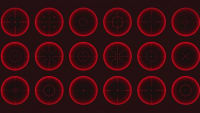
Photonics & Imaging Technology
Seeing Like a Butterfly: Optical Invention Enhances Camera Capabilities
Photonics & Imaging Technology
Comparing Sensitivity of Thermal Imaging Cameras Modules
Photonics & Imaging Technology
New Imaging Method Reveals Concealed Objects
Aerospace & Defense Tech Briefs
Panoramic Thermal Imaging Technology
Aerospace & Defense Tech Briefs
Thermal-to-Visible Face Recognition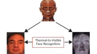
Photonics & Imaging Technology
Harnessing SWIR Line Scan Imaging Technology
Aerospace & Defense Tech Briefs
Directed-Energy System to Defeat Small Unmanned Aircraft System Swarms
Tech Briefs
Multi-Spectral Imaging Pyrometer
Photonics & Imaging Technology
Thermal Imaging: How Does It Work?

Photonics & Imaging Technology
Need for Larger Space Telescope Inspires Lightweight Flexible Holographic Lens

Aerospace & Defense Tech Briefs
Shortwave Infrared Sensors: A New Way to See
Photonics & Imaging Technology
Thermal Imaging — Making Hidden Details Visible
Tech Briefs
Airborne Background Oriented Schlieren Technique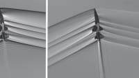
Tech Briefs
A Near-Perfect Blackbody Calibration Target
Overview
The technical report titled "Calibrated Long-Wave Infrared (LWIR) Thermal and Polarimetric Imagery of Small Unmanned Aerial Vehicles (UAVs) and Birds," authored by Kristan P. Gurton and published by the US Army Research Laboratory in August 2018, focuses on the development and application of advanced imaging techniques for detecting small UAVs and birds. The report is particularly relevant to agencies within the Department of Defense (DOD) and the private sector, which are increasingly interested in effective methods for identifying these aerial entities at ranges of 1 to 5 kilometers.
The document begins with an introduction to the challenges associated with detecting small UAVs, emphasizing the need for improved detection techniques. It discusses the capabilities of Long-Wave Infrared (LWIR) polarimetric cameras, which are designed to capture detailed thermal and polarimetric imagery. This technology is crucial for distinguishing between different types of aerial objects based on their thermal signatures and polarization characteristics.
The report details the calibration process for LWIR and polarimetric imagery, ensuring that the data collected is accurate and reliable. It presents results from various experiments that demonstrate the effectiveness of these imaging techniques in identifying and classifying small UAVs and birds. The analysis section delves into the implications of the findings, discussing how calibrated imagery can enhance situational awareness and improve detection capabilities in various operational contexts.
In the summary and conclusion, the report reiterates the significance of using calibrated LWIR and polarimetric imagery for aerial detection. It highlights the potential applications of this technology in military operations, wildlife monitoring, and other fields where aerial surveillance is critical. The findings suggest that these advanced imaging techniques can provide a substantial advantage in identifying and tracking small UAVs and birds, thereby contributing to enhanced safety and operational effectiveness.
Overall, the report serves as a comprehensive resource for understanding the advancements in LWIR and polarimetric imaging technologies, their calibration, and their practical applications in detecting small aerial vehicles. It underscores the importance of continued research and development in this area to meet the evolving challenges faced by defense and surveillance agencies.
Top Stories
NewsSensors/Data Acquisition
![]() Microvision Aquires Luminar, Plans Relationship Restoration, Multi-industry Push
Microvision Aquires Luminar, Plans Relationship Restoration, Multi-industry Push
INSIDERRF & Microwave Electronics
![]() A Next Generation Helmet System for Navy Pilots
A Next Generation Helmet System for Navy Pilots
INSIDERWeapons Systems
![]() New Raytheon and Lockheed Martin Agreements Expand Missile Defense Production
New Raytheon and Lockheed Martin Agreements Expand Missile Defense Production
NewsAutomotive
![]() Ford Announces 48-Volt Architecture for Future Electric Truck
Ford Announces 48-Volt Architecture for Future Electric Truck
INSIDERAerospace
![]() Active Strake System Cuts Cruise Drag, Boosts Flight Efficiency
Active Strake System Cuts Cruise Drag, Boosts Flight Efficiency
ArticlesTransportation
Webcasts
Aerospace
![]() Cooling a New Generation of Aerospace and Defense Embedded...
Cooling a New Generation of Aerospace and Defense Embedded...
Energy
![]() Battery Abuse Testing: Pushing to Failure
Battery Abuse Testing: Pushing to Failure
Power
![]() A FREE Two-Day Event Dedicated to Connected Mobility
A FREE Two-Day Event Dedicated to Connected Mobility
Automotive
![]() Quiet, Please: NVH Improvement Opportunities in the Early Design Cycle
Quiet, Please: NVH Improvement Opportunities in the Early Design Cycle
Electronics & Computers
![]() Advantages of Smart Power Distribution Unit Design for Automotive &...
Advantages of Smart Power Distribution Unit Design for Automotive &...
Unmanned Systems
![]() Sesame Solar's Nanogrid Tech Promises Major Gains in Drone Endurance
Sesame Solar's Nanogrid Tech Promises Major Gains in Drone Endurance