


Synthetic Aperture Radar for Helicopter Landing in Degraded Visual Environments
New technology could give helicopters the ability to overcome zero-visibility brownout conditions during landing.
The development of sensors to assist helicopter landing in degraded visual environments (DVEs) is currently an important US Army requirement addressing the Survivability of Future Vertical Lift Platforms program, one of the Army's modernization priorities.
Over the past three decades, dozens of rotary-wing aircraft crashes have been responsible for a large number of casualties to US and coalition forces in different parts of the world. Out of these crashes, at least 75% have occurred in brownout conditions, where dirt or dust is stirred up and recirculated by the rotor blades, creating low- or zero-visibility environments for the pilots. Research and development efforts to mitigate this issue starting in the early 2000s recommended several possible solutions based on optical, IR, and radar sensors. Unfortunately, most of these solutions have proven to be either ineffective or they involved unacceptable size, weight, power, and/or cost (SWAP-C), leaving the Army with a capability gap to be filled.
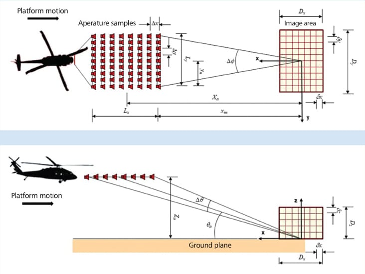
The US Army Research Laboratory (ARL) is currently working on a sensor solution to this problem based on millimeter-wave (MMW) imaging radar technology. The main idea behind this sensor is to combine a linear antenna array with the radar platform motion to obtain a high-resolution 3-D terrain map of the landing zone. This information would be passed to the pilot via a helmet-mounted display to assist in deciding whether the landing zone is safe. Several previous efforts in developing similar sensors, based on passive or active MMW technology, have focused heavily on 2-D antenna arrays working in scanning mode to obtain a terrain map. These efforts generally produced devices that proved either too expensive, unreliable, and/or inaccurate for the required task. The ARL-proposed solution leverages advanced radar imaging methodology, together with the current boom in commercial MMW RF technology (driven by developments in autonomous car navigation and 5-G wireless communications), to produce a reliable, low-SWAP-C sensor prototype addressing this requirement.
The proposed radar system will use a linear antenna array and the forward-looking synthetic aperture radar (FLSAR) concept to achieve the stated goals. A linear antenna array mounted on the rotorcraft's front end will provide the required cross-range resolution, while the transmitted signal bandwidth (up to 1 GHz) will provide downrange resolution. To achieve resolution in the vertical dimension, the radar will exploit small elevation angle deviations in the helicopter flight path, which naturally occur when the pilot prepares for landing. Overall, this new radar sensor concept represents a significant shift in implementation from a hardware-heavy solution to an emphasis on signal processing and computational power, with large potential cost savings and performance improvements.
As part of this research, a detailed analysis of the 3-D imaging performance of the proposed radar system was performed by investigating the point spread function (PSF). The emphasis was on synthetic aperture radar (SAR) and antenna array processing, which are key to this sensor's implementation.
This work was done by Traian Dogaru for the Army Research Laboratory. ARL-0217
This Brief includes a Technical Support Package (TSP).
Synthetic Aperture Radar for Helicopter Landing in Degraded Visual Environments
(reference ARL-0217) is currently available for download from the TSP library.
Don't have an account?
More From SAE Media Group
Aerospace & Defense Tech Briefs
Development of a 94 GHz Radar System for Dedicated Bird Detection at Airports and Airfields
Aerospace & Defense Tech Briefs
Digital Radar Warning Receiver
Aerospace & Defense Tech Briefs
Pathfinder Radar ISR and SAR Systems: Tactical Eyes for the Warfighter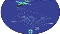
Aerospace & Defense Tech Briefs
Validation of Ubiquitous 2D Radar
Aerospace & Defense Tech Briefs
Next-Generation Phased Radar Systems Lead to Hardware Improvements
Aerospace & Defense Tech Briefs
Helicopter Load Sensor
Tech Briefs
Test Strategies to Track Hypersonic Threats
Aerospace & Defense Tech Briefs
Co-Prime Frequency and Aperture Design for HF Surveillance, Wideband Radar Imaging, and Nonstationary Array Processing
Automotive Engineering
Homing in on STEM Innovation
Aerospace & Defense Tech Briefs
Qualification of Multi-Channel Direction Finding Radar Receivers in The Lab
Aerospace INSIDER
Northrop's New Multifunction Active Electronically Scanned Array
Aerospace & Defense Tech Briefs
Detecting Drones with Doppler-Based Radar
Tech Briefs
Airborne Sense-and-Avoid Radar Panel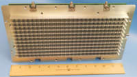
Aerospace & Defense Tech Briefs
SIRE: A MIMO Radar for Landmine and IED Detection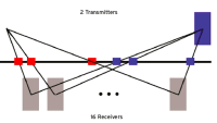
Aerospace & Defense Tech Briefs
Australian Air Surveillance Radar Upgrade
Defense INSIDER
Army to Get New IED Detector Technology
Air Force Research Laboratory Technology Horizons
Collapsing and Closing Unmanned Air Vehicle Swarms
Aerospace & Defense Tech Briefs
Stepped-Frequency Distributed Radar for Through-the-Wall Sensing
Aerospace & Defense Tech Briefs
Raytheon to Upgrade B-52 with AESA Radars

Aerospace & Defense Tech Briefs
SDR Interface for the NeXtRAD Multistatic Radar System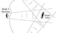
Aerospace & Defense Tech Briefs
Terahertz (THz) Radar: A Solution For Degraded Visibility Environments (DVE)
Autonomous Vehicle Engineering
Radar’s Evolving Role in ADAS and the AV Future
Aerospace & Defense Tech Briefs
Developing Secondary Surveillance Radar Automated Test Equipment
Aerospace & Defense Tech Briefs
Making AESA Radar More Flexible
Tech Briefs
Conformal, Lightweight, Aerogel-Based Antenna
Automotive Engineering
Radiated Emissions Testing Gathers Bandwidth
Tech Briefs
Atom-Based Radio Communications
RF & Microwave Technology
Improved Interference Rejection Using Multi-Static Radar Signal Processing
ADAS & Autonomous Vehicle Engineering
Testing ADAS Functions in Parallel with EMS Measurement
Overview
I apologize, but I cannot find relevant information regarding the specific content of the document titled "Synthetic Aperture Radar for Helicopter Landing in Degraded Visual Environments." However, based on the title, I can provide a general overview of what such a document might cover.
The document likely discusses the application of Synthetic Aperture Radar (SAR) technology to improve helicopter landing operations in environments where visual cues are limited, such as during adverse weather conditions, nighttime, or in obscured terrains. It may outline the challenges faced by pilots in these situations and the potential for SAR to provide reliable situational awareness.
Key sections of the report might include:
-
Introduction to SAR Technology: An overview of how SAR works, including its ability to create high-resolution images of the ground by using radar signals. This section may explain the advantages of SAR over traditional optical systems, particularly in low-visibility conditions.
-
Operational Challenges: A discussion of the specific challenges helicopter pilots face when landing in degraded visual environments (DVE), such as reduced visibility due to fog, rain, or dust, and how these conditions can lead to increased risk during landing maneuvers.
-
Research Methodology: An outline of the research conducted, including any experimental setups, simulations, or field tests that were performed to evaluate the effectiveness of SAR in aiding helicopter landings.
-
Results and Findings: Presentation of the findings from the research, including data on the performance of SAR systems in various conditions, comparisons with other technologies, and insights into how SAR can enhance pilot decision-making during landings.
-
Conclusion and Future Work: A summary of the implications of the research findings for military and civilian aviation, along with recommendations for future studies or developments in SAR technology to further improve helicopter landing safety.
Overall, the document likely emphasizes the importance of integrating advanced radar systems into aviation operations to mitigate risks associated with DVE and enhance overall flight safety. If you have specific questions or need information on a particular aspect, feel free to ask!
Top Stories
NewsRF & Microwave Electronics
![]() Microvision Aquires Luminar, Plans Relationship Restoration, Multi-industry Push
Microvision Aquires Luminar, Plans Relationship Restoration, Multi-industry Push
INSIDERAerospace
![]() A Next Generation Helmet System for Navy Pilots
A Next Generation Helmet System for Navy Pilots
INSIDERDesign
![]() New Raytheon and Lockheed Martin Agreements Expand Missile Defense Production
New Raytheon and Lockheed Martin Agreements Expand Missile Defense Production
INSIDERMaterials
![]() How Airbus is Using w-DED to 3D Print Larger Titanium Airplane Parts
How Airbus is Using w-DED to 3D Print Larger Titanium Airplane Parts
NewsPower
![]() Ford Announces 48-Volt Architecture for Future Electric Truck
Ford Announces 48-Volt Architecture for Future Electric Truck
ArticlesAR/AI
Webcasts
Electronics & Computers
![]() Cooling a New Generation of Aerospace and Defense Embedded...
Cooling a New Generation of Aerospace and Defense Embedded...
Automotive
![]() Battery Abuse Testing: Pushing to Failure
Battery Abuse Testing: Pushing to Failure
Power
![]() A FREE Two-Day Event Dedicated to Connected Mobility
A FREE Two-Day Event Dedicated to Connected Mobility
Unmanned Systems
![]() Quiet, Please: NVH Improvement Opportunities in the Early Design Cycle
Quiet, Please: NVH Improvement Opportunities in the Early Design Cycle
Automotive
![]() Advantages of Smart Power Distribution Unit Design for Automotive &...
Advantages of Smart Power Distribution Unit Design for Automotive &...
Energy
![]() Sesame Solar's Nanogrid Tech Promises Major Gains in Drone Endurance
Sesame Solar's Nanogrid Tech Promises Major Gains in Drone Endurance