


GPS Enabled Semi-Autonomous Robot
Combining GPS signals with acoustic and encoder data gives a robot the ability to determine its location and orientation within a reference frame.
The primary objective of this research is to integrate GPS and local sensory data to allow a robot to operate semi-autonomously outside of a laboratory environment. The Pioneer 3-AT, a robust platform capable of operating in the outdoors, is utilized in this project. The P3-AT has acoustic sensors that can calculate distances to obstacles and encoders that calculate how much each wheel has turned. In a laboratory environment, sensory and encoder information can be used to triangulate position or measure distance and direction traveled from a known starting point. Operating outdoors limits the effectiveness of both systems as the obstacles are not known and wheels can often slip and slide on different surfaces. This necessitates external data to determine the location of the robot. GPS was chosen to provide that data. GPS, acoustic, and encoder data were integrated within MATLAB and provided control signals to the robot.

One of the core tenets of robotics is localization: the ability of a robot to determine its location and orientation within a reference frame. Without knowing where it is in space, a robot is useless. It will be unable to navigate to a goal as it will not know in which direction to travel or even whether to stop should it stumble upon the goal by chance.
In wheeled robotic platforms, localization is conducted with encoders. Encoders measure how much each wheel turns. From a known starting point, a robot's position and orientation can be calculated through this measurement; however, localization based on encoders is susceptible to error outside of a laboratory environment. In a natural environment, the robot's wheels roll across various different surfaces. Wheel slippage encountered when operating on gravel, dirt, grass, or other mediums introduces localization error. To operate effectively in such mediums, additional information is required.
GPS is a 24-hour-a-day, all-weather navigation system. It provides navigation information accurate to within a few meters. By determining the goal in GPS coordinates and utilizing a GPS receiver (BU-353S4) onboard the robot, we see that the system can counter the encoder error and achieve accurate outdoor navigation.
On its own GPS is not enough. At slow speeds GPS has difficulty calculating directional change, and a refresh rate of one Hz leaves time between updates for the robot to move and not know where it is. By combining the two systems — GPS and encoders — the advantages of each are used to counter the other's weaknesses.
The design and testing of the control platform takes place in three steps. First, the GPS signal provided by the BU-353S4 is analyzed using a laptop computer as a test platform. The mobility of the laptop computer is a requirement as there is no GPS signal within the laboratory. Once the signal has been analyzed and a MATLAB platform has been developed to extract the specific information needed for this project from the signal as a whole, that platform is transferred to the SlimPRO SP675P microcomputer mounted on the P3-AT. The second step in the process is to use the SP575P to provide control inputs to the P3-AT and to demonstrate an ability to navigate to a goal defined in GPS coordinates within an environment free of obstacles. This requires comparing the user-defined goal and the robot's current position to determine the distance and direction between the two. Once the robot is able to navigate to a goal, the third and final step is to implement potential field path planning to allow the robot to make decisions and avoid obstacles on its way to the goal.
The platform developed for this project provides a foundation for future research. Incorporating additional sensory components such as a magnetometer or laser range finder creates a robot capable of much more accurate navigation and obstacle avoidance.
This work was done by Connor F. Bench for the Naval Postgraduate School. NPS-0003
This Brief includes a Technical Support Package (TSP).
GPS Enabled Semi-Autonomous Robot
(reference NPS-0003) is currently available for download from the TSP library.
Don't have an account?
More From SAE Media Group
Aerospace & Defense Tech Briefs
Systems Engineering Approach to Develop Guidance, Navigation and Control Algorithms for Unmanned Ground Vehicle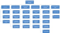

Aerospace & Defense Tech Briefs
Localization and Mapping of Unknown Locations with Unmanned Ground Vehicles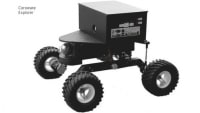

Tech Briefs
Algorithm Designs Soft Robots That Sense
Motion Design
Algorithm Helps Swarming Robots Avoid Collisions
Aerospace & Defense Tech Briefs
3D Data Acquisition Platform for Human Activity Understanding

Tech Briefs
Providing Robots a Soft Touch Using 3D Printing
Aerospace & Defense Tech Briefs
Digital Twins: How The Digital Replica Concept Is Used By Robotic Systems
Motion Design INSIDER
Simulation-Based Pipeline Tailors Training Data for Dexterous Robots
Aerospace & Defense Tech Briefs
Distributed, Collaborative Human- Robotic Networks for Search, Identify, and Track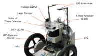


Motion Design
Shape-Shifting Robot Uses New Locomotion Strategy
Tech Briefs
5 Ws of a Self-Healing Robot
Motion Design
Autonomous Robot Opens Doors
Tech Briefs
Robot Reads Braille Twice as Fast as Humans
Tech Briefs
Compact 3D LiDAR Imaging System
Tech Briefs
Insect-Sized Agile Drones
Motion Design
Teaching Robots the Craft of Manipulating Materials
Robotics & Automation INSIDER
AI Yields ‘Athletically Intelligent’ Robotic Dog
Tech Briefs
Products of Tomorrow
Robotics & Automation INSIDER
World’s Smallest Programmable, Autonomous Robots
Tech Briefs
Soft Robotics Perception System
Motion Design
A New Method to Improve Motion Planning for Robots
Robotics & Automation INSIDER
MIT Engineers Help Multirobot Systems Stay In the Safety Zone
Motion Design
Faster Path Planning for Rubble-Roving Robots
Overview
The document is a thesis authored by Connor F. Bench at the Naval Postgraduate School in September 2017, focusing on the integration of Global Positioning System (GPS) data with local sensory information to enhance the semi-autonomous navigation capabilities of robots in outdoor environments. The research specifically utilizes the Pioneer 3-AT robotic platform, which is equipped with various sensors, including acoustic sensors and encoders, to facilitate navigation and obstacle avoidance.
The primary objective of the study is to develop a system that allows the robot to operate effectively in real-world outdoor settings, where GPS signals can be unreliable due to factors such as signal loss or interference. By combining GPS data with local sensory inputs, the research aims to create a more robust navigation solution that can adapt to changing environmental conditions.
The thesis outlines the methodology employed in the research, detailing the algorithms and techniques used to process the sensory data and integrate it with GPS information. The author conducts experiments to evaluate the performance of the robot in various scenarios, assessing its ability to navigate complex terrains and avoid obstacles while maintaining a reliable position estimate.
Key findings of the research indicate that the integration of GPS and local sensory data significantly improves the robot's navigation accuracy and reliability. The results demonstrate that the robot can successfully navigate through outdoor environments, even in the presence of GPS signal degradation. The study also highlights the importance of real-time data processing and the need for adaptive algorithms that can respond to dynamic changes in the environment.
In conclusion, this thesis contributes to the field of robotics by providing insights into the challenges and solutions associated with outdoor navigation. The findings underscore the potential for enhancing robotic systems through the integration of multiple data sources, paving the way for more advanced semi-autonomous robots capable of operating in diverse and unpredictable environments. The research not only advances academic knowledge but also has practical implications for applications in areas such as search and rescue, agriculture, and environmental monitoring.
Top Stories
INSIDERManufacturing & Prototyping
![]() How Airbus is Using w-DED to 3D Print Larger Titanium Airplane Parts
How Airbus is Using w-DED to 3D Print Larger Titanium Airplane Parts
NewsRF & Microwave Electronics
![]() Microvision Aquires Luminar, Plans Relationship Restoration, Multi-industry Push
Microvision Aquires Luminar, Plans Relationship Restoration, Multi-industry Push
INSIDERAerospace
![]() A Next Generation Helmet System for Navy Pilots
A Next Generation Helmet System for Navy Pilots
ArticlesManned Systems
![]() Accelerating Down the Road to Autonomy
Accelerating Down the Road to Autonomy
INSIDERWeapons Systems
![]() New Raytheon and Lockheed Martin Agreements Expand Missile Defense Production
New Raytheon and Lockheed Martin Agreements Expand Missile Defense Production
ArticlesAR/AI
![]() CES 2026: Bosch is Ready to Bring AI to Your (Likely ICE-powered) Vehicle
CES 2026: Bosch is Ready to Bring AI to Your (Likely ICE-powered) Vehicle
Webcasts
Semiconductors & ICs
![]() Advantages of Smart Power Distribution Unit Design for Automotive...
Advantages of Smart Power Distribution Unit Design for Automotive...
Unmanned Systems
![]() Quiet, Please: NVH Improvement Opportunities in the Early Design...
Quiet, Please: NVH Improvement Opportunities in the Early Design...
Electronics & Computers
![]() Cooling a New Generation of Aerospace and Defense Embedded...
Cooling a New Generation of Aerospace and Defense Embedded...
Power
![]() Battery Abuse Testing: Pushing to Failure
Battery Abuse Testing: Pushing to Failure
AR/AI
![]() A FREE Two-Day Event Dedicated to Connected Mobility
A FREE Two-Day Event Dedicated to Connected Mobility