


Researchers Develop New Maritime Target Detection System
SPAWAR Systems Center Pacific has developed RAPIER® full motion video (FMV), a maritime target detection, tracking, and identification solution that quickly and automatically analyzes video, alerts analysts of important targets, and outputs target information.
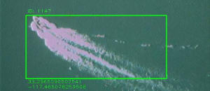
At the core of RAPIER FMV is an object detection system that uses basic signal processing and machine learning approaches. The system maintains a high level of performance without making prior assumptions about foreground- background characteristics. It is robust to variations in illumination, ever-changing background characteristics and video quality, as well as abrupt changes in the perspective, size, appearance, and number of targets. RAPIER FMV also uses a unique detection method that aids in improving processing times.
Full motion video technology is increasingly being used for maritime surveillance. However, the immense amount of FMV data produced, lack of automation, and dependency on human analysis make processing and extracting intelligence from FMV challenging. Maritime characteristics such as sun glint, whitecaps, ship wakes, and ship size further complicate object detection and tracking in FMV. SPAWAR Systems Center Pacific’s RAPIER FMV fills the need for an automated process that can quickly and efficiently analyze maritime FMV by extracting meaningful information to assist analysts in improving FMV processing time. RAPIER FMV’s algorithms reduce the risk of false detection and lessen analyst workload.
RAPIER FMV has applications in military, search and rescue, vessel tracking, counter-piracy, harbor and port security, and other maritime applications. Key features of the technology include: processes 1080p video in real-time raw video streaming from unmanned aerial vehicles, and processes 640×480 video up to two times faster; supports real-time video feeds from manned and unmanned aircraft, satellite, ship-mounted, and shore-based sensors; supports recorded data; acquires and tracks multiple maritime targets simultaneously; processes color, black and white, electro-optical, and infrared video; provides simple and easy to read output formats for end users such as HTML tip sheet, KML (Google Earth™), shape files, XML, OTH-G, RIT, and others; displays detected and recognized targets; and annotates video streams with metadata, including sensor positions, coordinates, and time and date.
Source :
More From SAE Media Group
Aerospace & Defense Tech Briefs
Optimal UAS Assignments and Trajectories for Persistent Surveillance and Data Collection from a Wireless Sensor Network
Defense INSIDER
Computer Program Analyzes Intelligence Data
Aerospace & Defense Tech Briefs
Autonomous Surveillance Technologies Relating to Dismounted Soldiers
Aerospace & Defense Tech Briefs
ADS-B Classification Using Multivariate Long Short-Term Memory

Aerospace INSIDER
Aitech’s New Palm-Sized Satellite Enables Space-Based AI Processing
Aerospace & Defense Tech Briefs
Through-Wall Imaging System
Aerospace & Defense Tech Briefs
5 Startups Developing AI for Defense Application
Aerospace & Defense Tech Briefs
Human-Focused Research Aims to Enhance UAS Effectiveness, Readiness
Aerospace & Defense Tech Briefs
Adding Context to Full-Motion Video for Improved Surveillance and Situational Awareness
Aerospace & Defense Tech Briefs
AI Closes the Loop for Composites Manufacturing

Defense INSIDER
Controlling Drones with the Human Brain
Aerospace & Defense Tech Briefs
A 'STEP' Forward for Product Lifecycle Management
Aerospace & Defense Tech Briefs
New Swarm and Search AI Challenge Combines Machine Learning and UAS to Help Map Wildfires
Aerospace INSIDER
AI-Powered Radar Warning Receiver for Fourth Generation Aircraft
Defense INSIDER
Algorithms for Autonomous Marine Vehicles

Aerospace & Defense Tech Briefs
New Cyber Algorithm Shuts Down Malicious Robotic Attacks

Aerospace & Defense Tech Briefs
3D Radar
Defense INSIDER
Army Technique Enhances Robot Battlefield Operations
Defense INSIDER
Identifying Optimal Designs for Deep Neural Network Accelerators
Aerospace & Defense Tech Briefs
AIA Predicts Flying Air Taxis, Supersonic Air Travel, and Space Industry for 2050
Aerospace & Defense Tech Briefs
Legacy in Action: The Enduring Role of MIL-STD-1553B
Aerospace & Defense Tech Briefs
Army Researchers Develop Chemical Threat Scanning on the Fly

Top Stories
INSIDERManufacturing & Prototyping
![]() How Airbus is Using w-DED to 3D Print Larger Titanium Airplane Parts
How Airbus is Using w-DED to 3D Print Larger Titanium Airplane Parts
INSIDERManned Systems
![]() FAA to Replace Aging Network of Ground-Based Radars
FAA to Replace Aging Network of Ground-Based Radars
NewsTransportation
![]() CES 2026: Bosch is Ready to Bring AI to Your (Likely ICE-powered) Vehicle
CES 2026: Bosch is Ready to Bring AI to Your (Likely ICE-powered) Vehicle
NewsSoftware
![]() Accelerating Down the Road to Autonomy
Accelerating Down the Road to Autonomy
EditorialDesign
![]() DarkSky One Wants to Make the World a Darker Place
DarkSky One Wants to Make the World a Darker Place
INSIDERMaterials
![]() Can This Self-Healing Composite Make Airplane and Spacecraft Components Last...
Can This Self-Healing Composite Make Airplane and Spacecraft Components Last...
Webcasts
Defense
![]() How Sift's Unified Observability Platform Accelerates Drone Innovation
How Sift's Unified Observability Platform Accelerates Drone Innovation
Automotive
![]() E/E Architecture Redefined: Building Smarter, Safer, and Scalable...
E/E Architecture Redefined: Building Smarter, Safer, and Scalable...
Power
![]() Hydrogen Engines Are Heating Up for Heavy Duty
Hydrogen Engines Are Heating Up for Heavy Duty
Electronics & Computers
![]() Advantages of Smart Power Distribution Unit Design for Automotive...
Advantages of Smart Power Distribution Unit Design for Automotive...
Unmanned Systems
![]() Quiet, Please: NVH Improvement Opportunities in the Early Design...
Quiet, Please: NVH Improvement Opportunities in the Early Design...