


Synthesizing Pseudo-Finer-Resolution MODIS Data Products
A document discusses a methodology for synthesizing finerresolution data products from outputs of the Moderate Resolution Imaging Spectroradiometer (MODIS) instruments aboard NASA's Terra and Aqua satellites. Typical MODIS ocean color data have 1-km resolution, but those in five wavelength bands have 500-m resolution and those in two wavelength bands have 250-m resolution. Finer-resolution bio-optical-property data products improve our capability for monitoring coastal ocean and estuarine processes.
The methodology involves the use of the 250-m-resolution data, coupled with the 500-m- and 1-km-resolution data bilinearly interpolated to 250-m resolution, to synthesize remote-sensing reflectances that, after correction for atmospheric aerosols, have pseudo-250-m resolution. The aerosol correction utilizes data in two l-km-resolution near-infrared bands. Water-leaving radiances in the near-infrared bands are modeled from water-leaving radiances in visible bands using data from two 250-m-resolution short-wave-infrared bands. The resulting reflectances become inputs to algorithms that compute bio-optical-property products. The document presents examples in which four pseudo-250-m-resolution bio-optical-property products are compared with the corresponding 1-km-resolution products and with data gathered in situ.
This work was done by Sherwin Ladner, Juanita Sandidge, Paul Lyon, Robert A. Arnone, Richard W. Gould, Zhongping Lee, and Paul Martinolich of the Naval Research Laboratory for the Office of Naval Research.
ONR-0009
This Brief includes a Technical Support Package (TSP).
Resolution MODIS Data Products
(reference ONR-0009) is currently available for download from the TSP library.
Don't have an account?
More From SAE Media Group

Photonics & Imaging Technology
Ultra-Narrowband Optical Filters Pushing Boundaries from the UV to the LWIR
Photonics & Imaging Technology
Researchers Use Inkjet Printing to Make a Portable Multispectral 3D Camera
Tech Briefs
Global Fire Detection Constellation
Aerospace & Defense Tech Briefs
Automated Atmospheric Correction of Nanosatellites Using Coincident Ocean Color Radiometer Data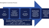
Aerospace & Defense Tech Briefs
This Laser Clock Could Transform Satellite Navigation Accuracy


Tech Briefs
Levitating Objects with Light
Photonics & Imaging Technology
The Latest Advancements in Optics


Tech Briefs
System for Thermal Imaging of Hot Moving Objects

Tech Briefs
Tunable, Narrow Linewidth, Chip-Scale Lasers
Imaging Technology
Mid-Infrared Reflectance Imaging of Thermal-Barrier Coatings

Photonics & Imaging Technology
New Frequency Comb Can Identify Molecules in 20-Nanosecond Snapshots


Photonics Tech Briefs
Wide-Field Optic for Autonomous Acquisition of Laser Link
Overview
The document discusses the development of finer spatial resolution optical properties derived from MODIS (Moderate Resolution Imaging Spectroradiometer) data, emphasizing the need for improved monitoring of coastal and estuarine processes. Traditional MODIS ocean color products are typically available at a spatial resolution of 1 kilometer (km), with some bands at 250 meters (m) and 500 m. However, the dynamic nature of coastal environments, influenced by factors such as tides, local winds, and river discharge, necessitates higher resolution imagery for accurate ecological monitoring.
The authors highlight the challenges associated with using 1 km products in coastal regions, where spatial variability in bio-optical properties is significantly greater than in open ocean areas. This variability complicates the validation of satellite products and increases uncertainty in measurements. To address these issues, the document outlines the integration of higher resolution bands (250 m and 500 m) with the standard 1 km bands to produce pseudo-250 m resolution bio-optical properties. This approach aims to enhance the accuracy of remote sensing reflectances (Rrs) and improve atmospheric correction methods, which are particularly challenging in turbid coastal waters.
Recent advancements in atmospheric correction techniques have been developed to better handle the complexities of coastal environments. The Ocean Biology Processing Group (OBPG) at NASA's Goddard Space Flight Center has introduced capabilities to produce a full suite of MODIS ocean, near-infrared (NIR), and shortwave infrared (SWIR) channels at higher resolutions. These improvements allow for the application of new atmospheric correction methods that can yield more reliable bio-optical data.
The document emphasizes the importance of finer resolution products for validating ocean color data in coastal regions, where shorter spatial scales and greater variability demand more precise measurements. The authors advocate for the continued development of high-resolution satellite imagery to enhance our understanding of coastal processes and improve ecological monitoring efforts.
In summary, the document presents a comprehensive overview of the need for and benefits of finer spatial resolution optical properties from MODIS data, highlighting the advancements in atmospheric correction techniques and the integration of higher resolution bands to improve coastal monitoring capabilities.
Top Stories
INSIDERDesign
![]() How Airbus is Using w-DED to 3D Print Larger Titanium Airplane Parts
How Airbus is Using w-DED to 3D Print Larger Titanium Airplane Parts
NewsSensors/Data Acquisition
![]() Microvision Aquires Luminar, Plans Relationship Restoration, Multi-industry Push
Microvision Aquires Luminar, Plans Relationship Restoration, Multi-industry Push
INSIDERManned Systems
![]() A Next Generation Helmet System for Navy Pilots
A Next Generation Helmet System for Navy Pilots
NewsAR/AI
![]() Accelerating Down the Road to Autonomy
Accelerating Down the Road to Autonomy
INSIDERDefense
![]() New Raytheon and Lockheed Martin Agreements Expand Missile Defense Production
New Raytheon and Lockheed Martin Agreements Expand Missile Defense Production
ArticlesAR/AI
![]() CES 2026: Bosch is Ready to Bring AI to Your (Likely ICE-powered) Vehicle
CES 2026: Bosch is Ready to Bring AI to Your (Likely ICE-powered) Vehicle
Webcasts
Semiconductors & ICs
![]() Advantages of Smart Power Distribution Unit Design for Automotive...
Advantages of Smart Power Distribution Unit Design for Automotive...
Unmanned Systems
![]() Quiet, Please: NVH Improvement Opportunities in the Early Design...
Quiet, Please: NVH Improvement Opportunities in the Early Design...
Electronics & Computers
![]() Cooling a New Generation of Aerospace and Defense Embedded...
Cooling a New Generation of Aerospace and Defense Embedded...
Automotive
![]() Battery Abuse Testing: Pushing to Failure
Battery Abuse Testing: Pushing to Failure
Transportation
![]() A FREE Two-Day Event Dedicated to Connected Mobility
A FREE Two-Day Event Dedicated to Connected Mobility