


Geospatial Accuracy of Small Unmanned Airborne System Data in the Coastal Environment
Determining the performance of image processing software could lead to better data collection strategy.
The purpose of this study was to assess the ability of commonly available COTS software to produce geometrically accurate orthometric mosaics and terrain models from low-altitude UAS imagery.
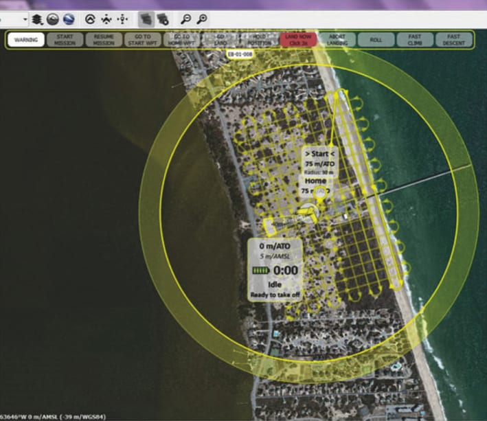
The coastal zone is a dynamic environment that requires temporal monitoring from flexible remote sensing tools. Changing weather, winds, and tides introduce difficulties when attempting to use sensors that are constrained by schedule to include satellite overflight or aircraft with hard collection dates and times. However, these collection requirements are well suited for small unmanned airborne system (UAS) platforms that can be deployed and made operational with minimal notice. Additionally, the low collection altitude, combined with short focal length imagers (often integrated into these small UAS platforms) are capable of producing very high spatial resolution horizontal and vertical data. These data have direct application for addressing many of the questions associated with coastal environments including beach and dune erosion, wetland conditions, impervious surface mapping, and species composition/health.
Along with the growth of small UAS aircraft has been the related development of many processing software packages to exploit these new data sources. Current commercial-off-the-shelf (COTS) and government-off-the-shelf software are capable of harnessing the multi-core, multi-graphical processing unit architectures. The four software packages selected for this study represent a cross section of use within the community and the USACE. The software packages chosen were: 1) Agisoft Photoscan, 2) SimActive Correlator3D, 3) Bentley Context Capture, and 4) École Polytechnique Fédérale de Lausanne (EPFL) Pix4D.
These packages are very efficient at addressing problems that require solving many independent calculations, which is exactly the case with photogrammetric processing. This capability has migrated photogrammetric processing (traditionally executed on high-end, expensive workstations) to low-cost commodity notebook personal computers (PCs). The UAS data processed by these software packages was collected from a Sensefly eBee UAS over the USACE Field Research Facility (FRF) in October 2015 and September 2016. Ground control had been placed and modified periodically over that time period (unrelated to the eBee flights) and was utilized to perform image mosaic georegistration and evaluate positional accuracy.
While most of the COTS tools have the same basic functionality, there are substantial differences with detailed capabilities, cost, ease of use, integration to platforms, and adaption to existing workflows. These parameters will differ by data requirements and final usage. Even within the U.S. Army Corps of Engineers (USACE), different laboratories and sections may desire/require different end products. However, some processes and products are relatively standard across users and applications, specifically the generation of the digital surface/elevation models as well as orthometric mosaics. These were the products generated and analyzed as part of this effort.
This work was done by Robert L Fischer, Jeffrey G. Ruby, Aaron J. Armstrong, and Jarrod D. Edwards, Nicholas J. Spore and Katherine L. Brodie for Army Engineer Research and Development Center. ERDC-0005
This Brief includes a Technical Support Package (TSP).
Geospatial Accuracy of Small Unmanned Airborne System Data in the Coastal Environment
(reference ERDC-0005) is currently available for download from the TSP library.
Don't have an account?
More From SAE Media Group

Aerospace & Defense Tech Briefs
Eyes In the Sky
Aerospace & Defense Tech Briefs
Maritime Unmanned Aircraft System
Aerospace & Defense Tech Briefs
Digital Twins: How The Digital Replica Concept Is Used By Robotic Systems
Tech Briefs
NASA Awards 2009 Software of the Year
Tech Briefs
Drones Use Machine Learning to Detect Landmines
Aerospace & Defense Tech Briefs
Drone Control System

Aerospace & Defense Tech Briefs
Playing Defense — Uncertain Regulations Stall the Implementation of Counter-UAS Technology in The U.S.
Aerospace & Defense Tech Briefs
New Technologies Tackle UAV Challenges
Photonics & Imaging Technology
Deep Learning in Machine Vision
Aerospace & Defense Tech Briefs
Automatic Drone Detection System
Aerospace & Defense Tech Briefs
UAV In-Flight Software Upgrades
Aerospace & Defense Tech Briefs
Adding Context to Full-Motion Video for Improved Surveillance and Situational Awareness
Tech Briefs
Algorithms Improve Quadrotor Drone Performance
Aerospace & Defense Tech Briefs
Connectors Lighten the SWaP Burden in UAV/MUMT Aircraft Electronics
Aerospace & Defense Tech Briefs
SAE International Launches Aerospace Technology Symposium at Japan Aerospace 2018
Photonics & Imaging Technology
Customized Drone Maps Glaciers
Tech Briefs
Remote Sensing for Smarter Forest Fire Fighting
Tech Briefs
Air Traffic Simulation Tool
Tech Briefs
Compact 3D LiDAR Imaging System
Aerospace & Defense Tech Briefs
Ground Control System
Aerospace & Defense Tech Briefs
Persistent Systems Auto-Tracking Antenna Adds Aircraft to Network, Enhances Data Sharing
Aerospace & Defense Tech Briefs
Autonomous “Wingman” Vehicles
Aerospace & Defense Tech Briefs
Drone Swarms: A Transformational Technology
Aerospace & Defense Tech Briefs
New Method to Measure Wind Speed Could Unlock Drones’ Potential

Overview
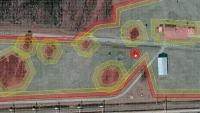
The report titled "Geospatial Accuracy of Small Unmanned Airborne System Data in the Coastal Environment" documents a study conducted by the U.S. Army Engineer Research and Development Center (ERDC) to assess the geospatial accuracy of imagery collected from unmanned airborne systems (UAS) in coastal environments. The study focuses on data acquired from a fixed-wing SenseFly eBee drone during two missions in October 2015 and September 2016 over the U.S. Army Corps of Engineers Field Research Facility in Duck, North Carolina.
The primary objective of the study was to evaluate the performance of four commercially available software packages—Agisoft Photoscan, SimActive Correlator3D, Bentley Context Capture, and Pix4D (EPFL)—in generating geometrically accurate orthometric mosaics and terrain models from low-altitude UAS imagery. The report highlights the importance of using flexible remote sensing tools in dynamic coastal environments, where traditional satellite and aircraft data collection methods may be constrained by fixed schedules.
The imagery data collected were processed to produce standard geospatial products, including digital surface models and orthometric mosaics. The accuracy of these products was assessed using 11 ground control points spread across a 70-hectare site. The results indicated that the accuracy of the generated models varied significantly depending on the software used, with three-dimensional root mean square errors ranging from 0.06 to 0.54 meters. This variation in accuracy was attributed to differences in photogrammetric processing approaches among the software packages.
The study also emphasized the critical role of image collection strategies, camera settings, and the design of ground control points in achieving high geospatial accuracy. The findings suggest that while UAS technology offers significant advantages for coastal monitoring, careful consideration of processing methods and data collection techniques is essential for reliable results.
Overall, the report underscores the potential of UAS in coastal research and management, providing valuable insights into the capabilities and limitations of different software tools in processing UAS imagery. The findings contribute to the ongoing development of remote sensing applications in coastal environments, with implications for various fields, including environmental monitoring, urban planning, and disaster response.
Top Stories
NewsSensors/Data Acquisition
![]() Microvision Aquires Luminar, Plans Relationship Restoration, Multi-industry Push
Microvision Aquires Luminar, Plans Relationship Restoration, Multi-industry Push
INSIDERRF & Microwave Electronics
![]() A Next Generation Helmet System for Navy Pilots
A Next Generation Helmet System for Navy Pilots
INSIDERWeapons Systems
![]() New Raytheon and Lockheed Martin Agreements Expand Missile Defense Production
New Raytheon and Lockheed Martin Agreements Expand Missile Defense Production
NewsAutomotive
![]() Ford Announces 48-Volt Architecture for Future Electric Truck
Ford Announces 48-Volt Architecture for Future Electric Truck
INSIDERAerospace
![]() Active Strake System Cuts Cruise Drag, Boosts Flight Efficiency
Active Strake System Cuts Cruise Drag, Boosts Flight Efficiency
ArticlesTransportation
Webcasts
Aerospace
![]() Cooling a New Generation of Aerospace and Defense Embedded...
Cooling a New Generation of Aerospace and Defense Embedded...
Energy
![]() Battery Abuse Testing: Pushing to Failure
Battery Abuse Testing: Pushing to Failure
Power
![]() A FREE Two-Day Event Dedicated to Connected Mobility
A FREE Two-Day Event Dedicated to Connected Mobility
Automotive
![]() Quiet, Please: NVH Improvement Opportunities in the Early Design Cycle
Quiet, Please: NVH Improvement Opportunities in the Early Design Cycle
Electronics & Computers
![]() Advantages of Smart Power Distribution Unit Design for Automotive &...
Advantages of Smart Power Distribution Unit Design for Automotive &...
Unmanned Systems
![]() Sesame Solar's Nanogrid Tech Promises Major Gains in Drone Endurance
Sesame Solar's Nanogrid Tech Promises Major Gains in Drone Endurance