Drone Control System
Kongsberg Geospatial
Ottawa, Ontario, Canada
1-800-267-7330
www.kongsberggeospatial.com
Kongsberg Geospatial, an Ottawa-based geospatial and defense technology company, recently introduced a new multi-domain control system for coordinating the use of drones in the battlespace.
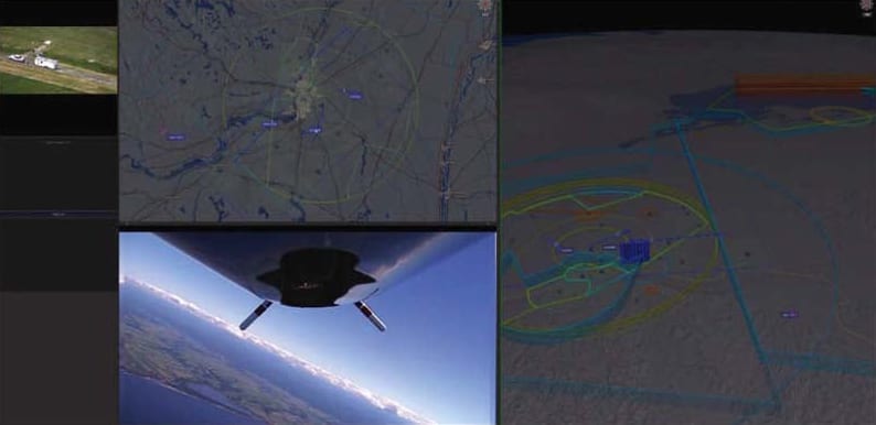
Over the past four years, the company has developed an airspace awareness system for operating unmanned aerial systems (UAS) beyond visual line-of-sight (BVLOS), called IRIS UxS. While it is primarily a civilian product, the IRIS system was developed based on Kongsberg Geospatial’s corporate experience developing civilian and military air traffic control systems, including the US Navy air traffic control system and embedded trainer used on aircraft carriers, and military command and control systems, including the US Navy AEGIS system.
The IRIS system was first developed to help commercial drone operators safely operate beyond visual line-of-sight. The system integrated real-time data from a variety of sensors and other sources to create a very accurate picture of the airspace around a drone. The platform presents users with 2D and 3D map and terrain data, aeronautical information such as aerodrome locations, obstacles and airspace, and real-time data from sensors, cameras, and weather data sources - all integrated within a single, common operating picture display.
Since then, IRIS has been developed into a full-fledged multi-platform control system integrated with a variety of autopilot systems, allowing a single operator to actively control multiple drones from a single station.
Kongsberg Geospatial has now announced a new, military-focused version of the IRIS system based on its participation in the NATO STANAG 4817 standard for multi-domain control stations. The new system collects and fuses data from a wide range of sensors, allowing operators to control multiple autonomous vehicles in a truly multi-domain mission theatre. This control system integrates different kinds of geospatial data and sensor input to create a composite operating picture which includes the airspace, 3D terrain, bathyscapy (undersea terrain visualization), and features from S-57 nautical charts. The system leverages a real-time DDS bus architecture and sensor fusion technology that allows operators to simultaneously track and operate drones in the air, on the water, and underwater.
Kongsberg Geospatial creates precision real-time software for mapping, geospatial visualization, and situational awareness. The company’s products are primarily deployed in solutions for air-traffic control, command and control, and air defense. The company hopes that their work relating to coordinating unmanned platforms with larger manned vehicles can help evolve new ways of visualizing multi-domain mission spaces for other command and control purposes.
For Free Info Visit Here .
Top Stories
INSIDERManufacturing & Prototyping
![]() How Airbus is Using w-DED to 3D Print Larger Titanium Airplane Parts
How Airbus is Using w-DED to 3D Print Larger Titanium Airplane Parts
INSIDERManned Systems
![]() FAA to Replace Aging Network of Ground-Based Radars
FAA to Replace Aging Network of Ground-Based Radars
NewsTransportation
![]() CES 2026: Bosch is Ready to Bring AI to Your (Likely ICE-powered) Vehicle
CES 2026: Bosch is Ready to Bring AI to Your (Likely ICE-powered) Vehicle
NewsSoftware
![]() Accelerating Down the Road to Autonomy
Accelerating Down the Road to Autonomy
EditorialDesign
![]() DarkSky One Wants to Make the World a Darker Place
DarkSky One Wants to Make the World a Darker Place
INSIDERMaterials
![]() Can This Self-Healing Composite Make Airplane and Spacecraft Components Last...
Can This Self-Healing Composite Make Airplane and Spacecraft Components Last...
Webcasts
Defense
![]() How Sift's Unified Observability Platform Accelerates Drone Innovation
How Sift's Unified Observability Platform Accelerates Drone Innovation
Automotive
![]() E/E Architecture Redefined: Building Smarter, Safer, and Scalable...
E/E Architecture Redefined: Building Smarter, Safer, and Scalable...
Power
![]() Hydrogen Engines Are Heating Up for Heavy Duty
Hydrogen Engines Are Heating Up for Heavy Duty
Electronics & Computers
![]() Advantages of Smart Power Distribution Unit Design for Automotive...
Advantages of Smart Power Distribution Unit Design for Automotive...
Unmanned Systems
![]() Quiet, Please: NVH Improvement Opportunities in the Early Design...
Quiet, Please: NVH Improvement Opportunities in the Early Design...


