


Report from SPIE 2017: Drones Spot Gas Leaks from the Sky
ANAHEIM, CA. During last week’s SPIE Defense + Commercial Sensing 2017 conference, panelists from industry, academia, and government demonstrated how miniaturized sensing platforms, and the unmanned aerial vehicles (UAVs) hosting them, can improve the detection of hazardous gas leakage.

The round-table event showcased many efforts to quantify methane, a component of natural gas. Aerial monitoring of pipelines, according to many presenters, will help to reduce the greenhouse gas contributor and protect the public from explosions and other harmful effects caused by emissions.
Finding the Leaks
The greater discussion of global warming has created additional emphasis on reducing breaks in the U.S. natural gas infrastructure — one that features over two million miles of distribution pipelines. Methane, when emitted into the air, absorbs the sun's heat and warms the atmosphere.
The natural gas sector has numerous leak points, ranging from the drilling-rig starting points, known as well pads, to specific parts of a city’s distribution system. Such localized sources create challenges for teams like those led by SPIE panelist Mark Zondlo, who has used UAVs to quantify methane emissions.
At the SPIE Defense + Commercial Sensing event on Wednesday, Mark Zondlo, Associate Professor of Civil and Environmental Engineering at Princeton University, spoke about his team’s experience with sending up UAVs to quantify methane emissions — an effort that began in 2011.
“We’re trying to look at leaks on the order of a well pad that is about ten meters by ten meters, or a transmission pipeline that may go 1,000 kilometers,” said Zondlo. “But the leak itself is small, so we have this really wide range of scales that we have to deal with.”
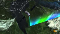
Accurate, precise, and stable gas detection via UAV is difficult, given the vehicle’s small payload, as well as possible measurement interference from the engine’s vibrations or electromagnetic interference (EMI). Even with a theoretically perfect sensor, narrow gas plumes tend to drift, and UAVs are also subject to turbulence, making the localization and quantification of leaks a challenge.
Laser-based sensors, specifically quantum-cascade lasers that emit in the mid-infrared portion of the electromagnetic spectrum, are compatible with small drone platforms due to their high sensitivity and compact footprint. The mid-IR range absorbs a range of molecules in addition to methane, including carbon dioxide and nitrogen.
Zondlo and fellow researchers developed a mid-infrared sensor, equipped with a 3.3-micron antimonide laser, and placed the system on a hexacopter. To address the challenges of in-flight stability, an in-line reference cell accounted for systematic drift during flight.
Flight tests were conducted around a compressor station, a facility that enables transport of natural gas from one location to another. The aerial demonstrations showed an improved detection of methane leaks from areas situated at altitudes of 500 meters.
NASA Methane Tests Take Off
For similar methane-detection purposes, Lance Christensen, senior scientist at NASA's Jet Propulsion Laboratory (JPL) and another featured panelist at SPIE Defense + Commercial Sensing 2017, placed miniature sensors on aerial robots.
Researchers from JPL and the Mechatronics, Embedded Systems and Automation (MESA) Lab at the University of California, Merced, began flight tests in late February of 2016. The experiments, funded by Pipeline Research Council International (PRCI), took place in central California at the Merced Vernal Pools and Grassland Reserve.
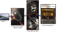
The JPL-led team placed a miniature tunable laser spectrometer on a small aerial robot quadcopter, a fixed-wing UAV, to find and quantify natural gas leaks. In the flight experiment, natural gas was released into the air. Rigged with a small tunable diode laser sensor, at 3.3. microns, the UAV sensed a leak about 35 meters from the site.
“Imagine these leaks in your neighborhood or along a pipeline,” said Christensen. “These are very small leaks that these systems can now detect and find at considerable distances.”
As part of the stochastic, or multi-variable, detection test, the drone flies back and forth to build up a probabilistic picture of the extent and size of a gas plume. In three to four minutes, the picture begins to form.
“You start to feel intuitively what the size of the leak is,” said Christensen.
Christensen believes that the technology has reached “parts per billion” sensitivity and can operate on small quadcopters. The challenge, he said, lies in figuring out how to use the data.
“Making a measurement of a gas plume while flying around tells you there’s a leak there, but you have to invert that measurement into something useful,” said Christensen. “You want to know how much that particular leak is. That’s the nature of the work we’re doing now.”
A More ‘Quantitative’ Option
According to many of the researchers on the SPIE panel, lasers provide a quantitative analysis compared to other detection methods like optical gas imaging (OGI). Optical gas imaging cameras use spectral wavelength filtering to visualize the infrared absorption of gas molecules and hydrocarbons.
Although the OGI systems have been considered an Environmental Protection Agency (EPA)-accepted standard for specific applications, such as inspection of large leaks at well heads, Mickey Frish, Manager of Industrial Sensors at Physical Sciences Inc., suggested that the optical gas imager, a passive technology, does not offer the quantitative measurement provided by lasers. Lasers, he said, also find specific gases, compared to OGI techniques that will show any and all hydrocarbons.
“When you use a laser, the number that you measure is independent of the background,” said Frish. “You get good, reliable numbers that you can use that to measure a leak rate.”
The Remote Methane Leak Detector (RMLD™), manufactured by Houston, TX-headquartered Heath Consultants and transferred from the Andover, MA-based Physical Sciences Inc., provides natural gas leak surveying capabilities. The 15-year-old tunable diode laser spectrometer has also been miniaturized and fixed onto a drone. The RMLD aims a laser beam at a target and measures the amount of methane based on backscatter, or reflection of radiation.
The panel ultimately shared an optimism for a UAV’s ability to detect gases from the air. Princeton University’s Mark Zondlo and other researchers on the SPIE panel — including Tim Day of San Diego, CA-based Daylight Solutions, IBM Research's William Green, and Ralph Taylor-Smith, General Partner of the technology-focused private equity investment firm Battelle Ventures and Innovation Valley Partners, based in Princeton, NJ — spent much of their presentations showcasing the benefits of miniaturized, drone-ready sensing systems.
“These leaks that we are detecting are going to happen, regardless of whether gas prices are low or high, and it’s a challenge we need to face,” said Zondlo.
Send questions or comments to
RELATED CONTENT:
Innovators at NASA’s Glenn Research Center have developed advanced hydrogen and hydrocarbon gas sensors capable of detecting leaks, monitoring emissions, and providing in situ measurements of gas composition and pressure.
Learn more about NASA’s Miniature Trace Gas Detector.
Read more Sensors tech briefs.
What do you think? Will UAVs change the ways we detect gases? What other applications do you envision? Start the conversation by using the form below.
More From SAE Media Group
NASA Spinoff
Methane Detector Sniffs Out Leaks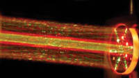
Tech Briefs
Methane Detector Sniffs Out Leaks
Sensor Technology
Drones Spot Gas Leaks From the Sky

NASA Spinoff
Mars Methane Detector Identifies Harmful Gas Leaks


Electronics & Sensors INSIDER
Sensors Driven by Machine Learning Sniff-Out Gas Leaks Fast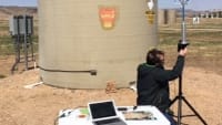

Aerospace & Defense Tech Briefs
Airborne Inspection Sensor Evolves with LiDAR, Mid-IR and Artificial Intelligence
Sensing Technology
Drones Can Detect Fires and Monitor Greenhouse Gas Emissions
Electronics & Sensors INSIDER
“Agricomb” Measures Multiple Gas Emissions From ... Cows
Aerospace Manufacturing and Machining INSIDER
NASA to Advance Unique 3D Printed Sensor Technology

Tech Briefs
Drones Use Machine Learning to Detect Landmines
Aerospace & Defense Tech Briefs
New Diamond Super-Material Enhances Aircraft Survivability
Electronics & Sensors INSIDER
Novel Technology Enhances Measurement Reliability of Methane Gas Emissions from Rice Paddy Fields
Photonics & Imaging Technology
Tackling Aircraft Laser Strikes from the Ground
Aerospace & Defense Tech Briefs
Combating Infrared Threats on the Battlefield
Aerospace & Defense Tech Briefs
Directed-Energy System to Defeat Small Unmanned Aircraft System Swarms
Sensor Technology
Next-Generation MEMS Multi-Gas Sensing
Sensor Technology
Sensing Hazardous Gases Can Save Lives
Sensor Technology
New Sensor Paves Way to Low-Cost Sensitive Methane Measurements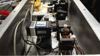
Tech Briefs
Evolution of the QWIP Detector
Tech Briefs
Laser-Light-Based Accelerometer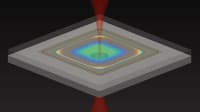


Tech Briefs
Wide-Area Chemical Sensor
Transcript
00:00:00 these natural gas lines that carry natural gas to our homes are buried three or 4 feet beneath the ground and when they have a break the natural gas starts to leak out and make its way to the surface and up into the atmosphere methane is a very potent greenhouse gas over the first 20 years it's 84 times more potent than carbon
00:00:23 dioxide and while most of these leaks are not an immediate safety threat they are a threat to the environment working together with DF and Colorado State University we equipped a handful of street view cars with methane analyzers and we've been driving around uh select US cities for the past few years now when the street view car drives around it's capturing 360° panoramic imagery
00:00:44 but with this project on top of that it's also measuring methane concentration every half second as the car drives down the street my role in this project is to look at the data that comes from these methane analyzers and to try to interpret that in light of natural gas leaks we're able to identify natural gas leaks throughout the Distribution Systems in cities and
00:01:05 measure how much methane is coming out from each of these leaks natural gas pipeline replacement projects like this are happening across the country throughout the year and they're expensive one of the goals of our project is to inform utilities about where the leakiest pipelines are so they can Target the replacement effort on those lines essentially we're turning
00:01:26 the street view Fleet into an environmental sensing platform so all the analysis of the of the air samples is done back here where we have this High Precision methane analyzer and this is where the air is analyzed it's drawn from the intake tubing in the front bumper by this pump and then there's a high Precision GPS unit on the rooftop all the data that's collected by these
00:01:45 instruments is analyzed by a computer that resides up on the driver's seat we take that data and run it through an algorithm that shows us not only where the leaks are but also how big the leaks are the result is a Google map on the DF website where anyone can go and see where these methane leaks are happening the environmental defense fund has been very focused and brought this
00:02:08 this problem of methane to the four and so that partnership is incredibly powerful this technology I think of as like having glasses we're finally able to see natural gas leaks For the First Time The methane mapping project puts information in the hands of utilities and Regulators in New Jersey the regulator and utility have in inated the data from
00:02:31 our project to prioritize nearly a billion dollars worth of infrastructure investment natural gas lines are everywhere that people are but they're buried and they're invisible what is exciting to me about our research is that we're making this infrastructure and the problems with this infrastructure visible to other people people often hear about climate change
00:02:51 and think that it's a very remote far away issue but this is one case where everyone can support local action that will make a difference
Top Stories
INSIDERDesign
![]() How Airbus is Using w-DED to 3D Print Larger Titanium Airplane Parts
How Airbus is Using w-DED to 3D Print Larger Titanium Airplane Parts
NewsSensors/Data Acquisition
![]() Microvision Aquires Luminar, Plans Relationship Restoration, Multi-industry Push
Microvision Aquires Luminar, Plans Relationship Restoration, Multi-industry Push
INSIDERManned Systems
![]() A Next Generation Helmet System for Navy Pilots
A Next Generation Helmet System for Navy Pilots
NewsAR/AI
![]() Accelerating Down the Road to Autonomy
Accelerating Down the Road to Autonomy
INSIDERDefense
![]() New Raytheon and Lockheed Martin Agreements Expand Missile Defense Production
New Raytheon and Lockheed Martin Agreements Expand Missile Defense Production
ArticlesAR/AI
![]() CES 2026: Bosch is Ready to Bring AI to Your (Likely ICE-powered) Vehicle
CES 2026: Bosch is Ready to Bring AI to Your (Likely ICE-powered) Vehicle
Webcasts
Semiconductors & ICs
![]() Advantages of Smart Power Distribution Unit Design for Automotive...
Advantages of Smart Power Distribution Unit Design for Automotive...
Unmanned Systems
![]() Quiet, Please: NVH Improvement Opportunities in the Early Design...
Quiet, Please: NVH Improvement Opportunities in the Early Design...
Electronics & Computers
![]() Cooling a New Generation of Aerospace and Defense Embedded...
Cooling a New Generation of Aerospace and Defense Embedded...
Automotive
![]() Battery Abuse Testing: Pushing to Failure
Battery Abuse Testing: Pushing to Failure
Transportation
![]() A FREE Two-Day Event Dedicated to Connected Mobility
A FREE Two-Day Event Dedicated to Connected Mobility